Creating uncertainty
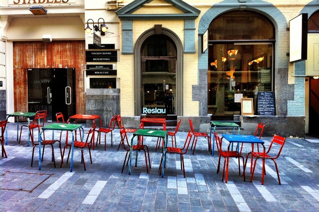
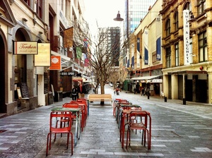
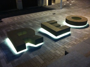
Elliot Street, Auckland. One of a number of new shared spaces throughout the central city.
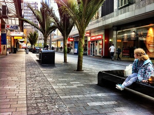
In some parts of downtown Auckland pedestrians now have the right of way. Auckland Council’s Ludo Campbell-Reid and Nazla Carmine provide some background to these new streets.
There’s a nice line in an article, in the now defunct AEN Journal, written by Pip Cheshire back in 2006. The architect refers to urban designer Stuart Niven, who “characterised the role of council urban design as ‘representing those not at the table when decisions are made.’” It’s a good observation, leading off from the idea that “the provision of a safe, attractive, vibrant city and inclusive city is too complex a task to be left to the happenstance of corporate decision making…”. There are other interests to be acknowledged, “building occupants, passersby, and citizens in general”.
Who’s job is that? Ludo Campbell-Reid could put his hand up. He used to be Auckland City Council’s “Design Champion”, which sounds a lot like being an advocate for “those not at the table”. However, his has been an evolving role since his arrival, back in 2006, from the United Kingdom, at the behest of then-mayor Dick Hubbard. Mayors may come and go but Campbell-Reid has played a longer game. He’s thrived, and so too have the city’s urban designers. In 2006, there were eight on staff at Auckland City Council. (Unfortunately, they weren’t Campbell-Reid’s staff – “I wasn’t their boss. I was their virtual boss.”) At the time of Auckland City Council’s demise there were 15, and now there’s 30.
Talking to Campbell-Reid you get the feeling that early in his tenure he was frustrated by a lack of teeth. Now he has better weapons in his armoury, most notably a “more powerful mandate” – sign-off on the region’s capital projects. His business card reflects a more sophisticated title, Manager Environmental Strategy & Policy Department, and his ambit has widened to include “responsibility for heritage for the whole region. That’s the delivery and the planning, and all air, land, water and coastal issues for the region.” That’s some list.
Ostensibly, I’ve met with Campbell-Reid and Nazla Carmine, project manager on Auckland Council’s CBD street upgrades, to discuss the roll-out of new shared spaces around the central city. There’s been plenty of talk about these spaces, and the streets in question, Darby, Elliot, Fort, Lorne and Kitchener, acknowledge pedestrians as having the right of way, and dispense with the niceties, such as curbs. However, the back story is as interesting as the detailing of the streets themselves. Why cede the authority of the car to the individual? That’s a rhetorical question for anyone who likes a characterful city, but it’s still politically challenging, probably for the most part because these streets are more expensive.
“The concept of pedestrian-friendly cities is a relatively new thing,” says Campbell-Reid. “Quite a few projects around the world are anti-car, and they’re polarising. We felt that if we came in with a pedestrian-only approach in a city that is addicted to the vehicle then we’re doomed to fail.”
It was time to look at alternative models, he says, because the city that we want is “the one we haven’t managed to achieve for many years”. The predominance of a transport-engineered city has seen the fast movement of traffic prioritised over the quality of place and amenity. “That has led to a certain type of city shape, form and function.”
“We also have the highest ownership of cars per head of capita. It’s not just me saying there is a problem here, there’s an addiction to the private motorcar and like heroin and alcohol, you can’t just switch it off.”
The concept of shared space was a proposition that went to the councillors, and a process of “cajoling and suggesting”, or more euphemistically, education, began. Overseas influences were sought to add heft to the argument, including Campbell-Reid’s “old boss”, Councillor Daniel Moylen, a conservative politician putting together the largest shared space projects in London.
Looking at other successful cities, usually those with a strong focus on pedestrianisation, can provide lessons about reclaiming the inner city.
“Go to Copenhagen,” says Campbell-Reid. “Everyone looks at photos of what they’ve done there and they says, ‘oh my god, it’s so wonderful’. Forty-years-ago Copenhagen was a carpark. Over successive years, the traffic engineers and Jan Gehl and other guys have started taking out bit by bit – almost by stealth. In time, you’ve suddenly got these new spaces.”
Other third parties were brought over to provide objective views. Jan Gehl, the Danish architect and urban designer, came out a few years ago to do a review. His thoughts? “We talk really well about the city that we want, yet we don’t deliver the city that we want because we are unprepared to make the hard decision that there’s a point when vehicles are no longer the dominant theme. It was really the paradigm shift between how much space you dedicate to people vis-à-vis to cars,” says Campbell-Reid.
“He felt that the documents we had were about a pedestrian-friendly and people-friendly city. You can’t deliver a city for everybody in every single place. If you take a certain approach, you’re marginalising a group of people who are the “movement economy”– the people network. If you can link them up you link up the economic opportunities. If you stop them then you’re breaking the city. So, Nelson, Hobson, Queen Street, when the speed limit was 50km/h, sever the city.”
The Queen Street upgrade was the first major project in a 10-year CBD upgrade programme. Its success, says Nazla Carmine, project manager for street upgrade works was a tipping point. “People started to the see the difference and actually wanted more change”.
“It was a huge project in terms of transforming streets in the CBD. It was hard-fought in many ways, but once we’d done it, people saw the benefits. That allowed us to push on to shared space, which is one step further down the design spectrum, where we could do more for the pedestrian.”
The initial streets upgraded under the 10-year plan were Swanson, Queen and Vulcan lane. In 2008, a review was undertaken and other streets with shared space potential connecting to Queen Street and the upgraded streets were identified.
Shared space, says Campbell-Reid, is based on psychology. “Traditional traffic engineering tries to create clarity between where people are and where traffic is. People have tended to be marginalised to the sides. With shared space you create uncertainty, so it becomes more about awareness, making eye contact, about citizenship.”
Traffic engineer Hans Monderman made shared space into a technical concept – and Campbell-Reid recounts one of the Dutchman’s more famous anecdotes. Monderman was in one of his shared spaces in Mälmo. A driver entered the street, winds down the window and says, ‘Excuse me, where can I park?’ Monderman says, “You can park where ever you think you should park.” And that about sums up shared space. It’s egalitarian, says Campbell-Reid. “New Zealand’s a democratic, socially accepting country. I think shared space really fits the kiwi psyche. This country’s full of really innovative people, so let’s put it on the ground and take it to market.
The Delineator: making shared spaces spaces for everyone
Nazla Carmine, project manager for CBD street upgrades team, says that in the UK there was a backlash against the shared space concept by the Royal Foundation for the Blind. Shared spaces remove cues, such as curbs and signage – for everybody, including those with visual and physical impairments. To avoid this in Auckland, Carmine’s team worked with disability groups to design a concept that allowed participation for all in shared spaces.
“We had the benefit of learning from overseas experience. We pretty much talked to every expert about shared space, but have created our a design that is appropriate to the Auckland context. We learnt that if these spaces were really going to be accessible then we needed to talk to people with accessibility issues so that we could come up with a design that would work for everyone.”
That involved a process of full consultation with key disability groups, such as the Royal NZ Foundation for the Blind and the Resource Mobility Centre. Through that a design feature was developed – a 1.8-2m wide strip of paving adjacent to the building line that is framed with a textured “tactile delineator strip”.
“This provides greater certainty for the most vulnerable groups. It’s tactile so it does the same job as a curb. It allows somebody with a visual impairment to identify that they are moving into a space that may have clutter or vehicles beyond it. The strip between the building line and the delineator is called the ‘accessible zone’; it’s completely clutter free. There’s no street furniture in this zone, and we’ve made sure that in the street trading policy and events policies that this strip remains clutter free: no business paraphernalia or no outdoor dining furniture.”