Downtown dilemma
The existing Queen Elizabeth Square “is regarded generally as an unsuccessful space”.
Joel Cayford is an urban planner, part-time lecturer at The University of Auckland's School of Architecture and Planning, and blogger-campaigner for Auckland planning issues. Here, he suggests that Auckland Council’s proposed sale of Queen Elizabeth Square and its management of redevelopment of the downtown block where it is situated leaves the public uninformed and unable to participate in the planning of this important part of Auckland City.

This is my first appearance in the journal of the New Zealand Institute of Architects and, given the number of major Auckland proposals where there is a public interest overlap between architecture and planning issues, it won’t be my last [Cayford’s piece appeared in Architecture New Zealand’s Sept/Oct 2015 issue] .
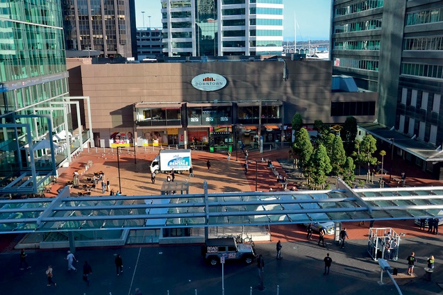
I’m writing here about Auckland’s downtown precinct, the area of land bounded by Lower Queen, Lower Albert and Quay Streets, and Customs Street West. At present the site is occupied by the HSBC and Zurich Towers (home of the NZIA), a Westfield shopping centre destined for demolition and a road rump left over from when the site was redeveloped 50 years ago.
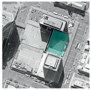
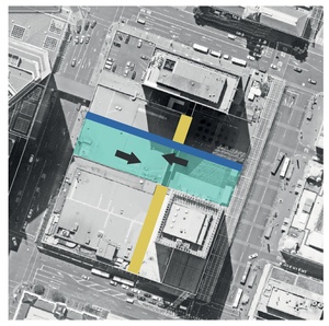
The 1,800m² road rump, which glories under the name of Queen Elizabeth Square, has become a highly contested piece of public space since Auckland Council decided last year that it should be sold, in principle. The sale has been sold to councillors as the necessary enabler of a major urban regeneration project, which will see much of downtown Auckland excavated to form a trench about 15m wide and 15m deep, running from the old Central Post Office building (Britomart Railway Station) through Queen Elizabeth Square in a gentle curve up and under Albert Street for the Central Rail Link.
The above-ground redevelopment after the tunnel is covered, will include a remodelled four-to-six-storeyed development across the entire area, along with a new tower at the corner of Customs Street West and Lower Albert Street.
A major public debate has erupted in Auckland over the potential sale of Queen Elizabeth Square, which is described in a Council report: “Queen Elizabeth Square functions primarily as a passive space: a thoroughfare to pass through rather than a space in which to linger. It is regarded generally as an unsuccessful space.
“This can be attributed in part to the lack of active built frontage onto it and the visual and physical severance from lower Queen Street created by the entrance to the underground rail platforms and glazed canopy that defines its eastern perimeter. Perhaps more critically, it is the orientation of Queen Elizabeth Square that is its greatest drawback, being cast in shadow by 1 Queen Street for significant portions of the day.”
I think this is a fair description. An unresolved planning issue is how best to compensate the city for the loss of public space that would follow its sale. ‘A Short History of the Sixties Downtown’ by Dennis Smith, published in the March/April 2013 issue of Architecture New Zealand, provides an excellent account of political and planning shenanigans that gave Auckland Queen Elizabeth Square and what stands there today.
My article takes up the story over the past few years and provides background to submissions that were lodged in July, against what is happening downtown, by the Auckland Architecture Association (AAA), the Auckland Branch of the NZIA, the Urban Design Forum and by Urban Auckland – The Society for the Protection of Auckland City and Waterfront Inc. Since investigating the 1990s’ privatisation and redevelopment planning of Auckland’s Princes Wharf for research I’m undertaking at The University of Auckland’s School of Architecture and Planning, I’ve become very interested – some might say unhealthily interested – in how that project happened and why it failed to deliver the public space and amenity promised in early plans.
I’m keen that Auckland avoids those historical mistakes in other Auckland urban regeneration projects. When the idea of selling Queen Elizabeth Square first came up at an Auckland Council meeting I attended last year, my interest was piqued but it was almost by accident that I discovered plans already existed for a 41-storeyed tower on the downtown Westfield site. I sought official information about the various resource consents and planning processes relating to number 7 Queen Street – the address of the Westfield Downtown Shopping Centre, which had, by then, been purchased by Precinct Properties for redevelopment and under which would pass a section of tunnel allowing the Central Rail Link (CRL) access into Britomart Railway Station.
I learned that Westfield had applied to Auckland City Council on 14 April 2007 to build a 41-storeyed tower and 471 basement car parks on the corner of Lower Albert and Customs Street West. It infringed controls relating to height and traffic. Nevertheless, and despite letters from Auckland Regional Transport Authority (ARTA) about the then-proposed CRL tunnel, and despite conflicting legal advice, Auckland City Council officers decided the application did not need to be notified publicly and consent was granted in April 2008 “without any issues of contention”.
A year after amalgamation, in August 2011, Auckland Council received another application from Westfield, this time to extend the life of that resource consent permit out to 2018. Westfield argues in its application that it “was unaware of the rail tunnel proposition when the decision was taken to invest in the proposed scheme and seek consent for the redevelopment of the site”. Yet, documents indicate Westfield met with ARTA almost a year before the original consent was granted. This time, the new super-city Auckland Council dealt with the extension application.
Despite Mayor Len Brown’s evident commitment to the CRL project, officers recommended the extension be dealt with using a non-notified process again. A single commissioner, sitting alone, took a few minutes to sign it off and the Auckland public remained none the wiser. The upshot is that, because planning consent for the proposed tower was settled before the planning designation was finalised for the CRL, Council has had to compensate Precinct Properties for potential basement parking ‘lost’ to make way for the tunnel.
I understand this cost is around $20,000,000 but don’t have access to confirming documents – par for the course for this whole downtown redevelopment project, which has been characterised by undisclosed deals between Auckland Council, Auckland Transport and Precinct Properties. The process largely ignores the broader public interest and leaves the public uninformed and unable to participate in the planning of this prominent and important part of Auckland City.
To be fair, Auckland Council has consulted the Urban Design Panel, whose list of members is a who’s who of Auckland’s professional architects, planners and urban designers, but a project like this, with its complex re-arrangements of public transport, public space and private development, requires greater scrutiny, opportunity for public submissions and recognition that options may emerge that have yet to be considered.
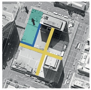
In recent weeks, various procedural steps that do require public notification and participation have been forced on Council and Precinct Properties. The first is Plan Change 79 which aims to change the planning controls and provisions over Queen Elizabeth Square – essentially to prevent it from being public space, enabling it for private development and also allowing it to be shaded by the tower that is proposed next door. The second is the need for a ‘road stop’ process on Queen Elizabeth Square because it is designated presently as ‘road’.
Together, these processes – which include various hurdles – would allow Queen Elizabeth Square to be sold privately and developed to a height of five or six storeys. Submissions were sought in July 2015 by notices published in the New Zealand Herald. The AAA has responded: “AAA has a long history of involvement in Central Auckland urban planning and architecture matters. It welcomes the opportunity that notification of this Plan Change provides to make submissions relating to proposals and plans to redevelop an area of downtown Auckland.
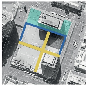
“However, AAA is concerned that the scope of submissions that relate specifically to the notified Plan Change is limited necessarily just to the area of Queen Elizabeth Square (QESQ) and specific matters, despite the fact that the development of QESQ clearly overlaps with, is integrated with and is part of development proposals affecting a much wider area of downtown Auckland, and which are of enormous public interest.
“AAA submits that the purpose of the Resource Management Act would be served best through promulgating and notifying a downtown precinct or quarter-wide plan change. Such an integrated approach would avoid issues associated with incrementalism and allow for a holistic consideration of the architecture, urban design and planning matters that arise from this redevelopment, including public space and public transport.
Furthermore, AAA notes with considerable concern that, while the Plan Change references the matter of public space provision to replace QESQ, neither it, nor any other process of which AAA is aware, ensures that provision to a commensurate standard. AAA cannot support an incremental measure that relegates compensating public space provision to some unspecified time in the future, particularly when the paucity and scarcity of available opportunities is considered.”
AAA explains these introductory submissions in more detail: “Several central area ‘precincts’ exist in close proximity to the subject land at QESQ and the downtown redevelopment area. These include Britomart, Quay Park, Viaduct Harbour and Wynyard Quarter. AAA submits that precinct-wide Plan Change processes that were carried out for those precincts – in accordance with the District Plan – identified public spaces and places, and ensured their protection and those using them from the adverse effects of buildings and other activities within those precincts.
“AAA submits that the whole of the downtown redevelopment, including the provision of public space, and proposed changes for public transport service provision, should be the subject of a precinct Plan Change for the whole area – not just QESQ. This would be consistent with the District Plan, give effect to the RMA and the Auckland Regional Policy Statement, and be consistent with provisions contained in the Proposed Auckland Unitary Plan.”
And: “AAA understands that a sum of some $27.2 million is projected from the sale of QESQ, which will be available to reinvest in public space, though the options that have been canvassed are all already in public ownership (sections of Queens Wharf, Ports of Auckland Admiralty Steps, sections of Quay Street or/and Lower Albert Street). AAA submits that more appropriate options for providing downtown public space exist – given that the whole of the downtown west area is to be redeveloped.
“A more successful public space than the present QESQ could be provided within the existing downtown west footprint. It could, for example, front onto Lower Albert Street or it could front onto the corner of Lower Albert and Quay Streets. Such locations would be away from the shading effects of both 1 Queen Street and the proposed tower, and would benefit from and be of benefit to the kinds of activated frontages that could be built as part of the redevelopment.
“These alternatives should be considered as part of this downtown Auckland redevelopment. They are the kinds of alternative that AAA would expect to see canvassed in a framework plan or structure plan that should be produced within or as part of a precinct-wide Plan Change.”
Interestingly, Auckland Council has commissioned Reset Urban Design to conduct an open space evaluation of Auckland’s downtown area, which found: “Historically, the provision of public open space has not been planned and, currently, it is underprovided; there is an increasing inner-city population and tourist numbers; surveys reveal strong demand for a range of additional facilities…”
Reset notes, “High-quality open space is a critical part of a successful urban fabric… the picture of open space, currently, is not one of a strongly coherent element. There is huge potential for more variety, greater volume and more coherence and connectivity. Since 2000, there has been more open space added: e.g. Wynyard Quarter and Britomart.”
Reset advises: “Currently, in the downtown area, there is a massive amount of comprehensive redevelopment. Nothing, specifically, is considered for Queen Elizabeth Square, which is in the centre of the downtown area; strategic relationships and fit should be a major focus for the best joined-up outcomes…”
I agree. It makes me wonder what Council does with such advice. I’ll end with the elephant in the room: transport generally and Auckland Transport specifically. Bus interchange functions, presently located in Lower Queen Street, are being relocated to Lower Albert Street and into Britomart. Precinct proposes a three-lane-wide entry and exit across the pavement into Lower Albert Street from expanded underground parking and transport demands.
How pedestrian, bus and general traffic conflicts in Lower Albert Street are to be resolved remains to be seen, and how Lower Queen Street might function without buses but with a proposed tram also remains to be seen. None of these plans has been made public.
The responsible way forward now is a comprehensive plan for downtown, providing for public spaces, public transport services and Precinct Properties’ development proposals. Queen Elizabeth Square incrementalism doesn’t cut the mustard.
For the previous ArchitectureNow article on the sale of the Queen Elizabeth Square, see here.