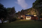
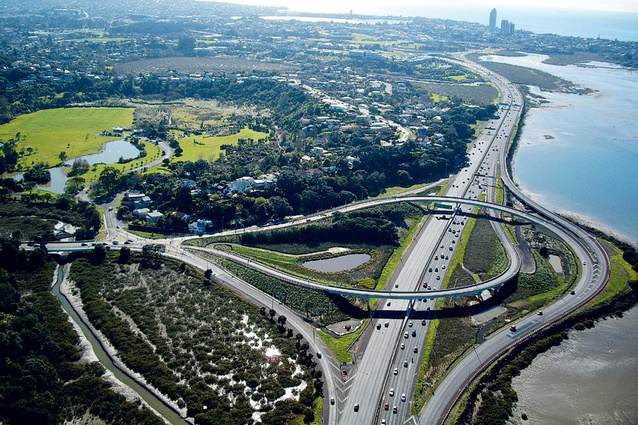
Onewa interchange
The motorway interchange at Onewa was planted with species that reflect the open coastal location on the shores of Shoal Bay.

The higher embankments were planted in pohutukawa; low flats, representing coastal low marshlands, were planted in swathes of oioi wetland grasses.
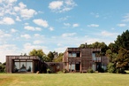
The Onewa Interchange on Auckland’s North Shore has undergone extensive roading improvements sparked by the construction of the award-winning and immensely successful Northern Busway transport system between Auckland City and the North Shore. The landscape design dealt sustainably with the challenging estuarine conditions and enhanced the existing environment for the local bird and plant life and road users.
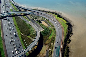
The new interchange includes two overbridges to replace the original overbridge, and a new dedicated bus lane and bridge. The interchange is located on the edge of Shoal Bay, on the flats of reclaimed land and at the junction of three key elements: cliffs, flats and water. The planting scheme has adopted these basic elements in the selection of pohutakawa and coastal flaxes of the embankments (cliff), the salt meadow planting (flats) and the wetland pond and swale planting (water).
Although the new bridge structures are low with sweeping visual lines, the arrangements are visually complex. To reduce this effect, the strong simple hierarchy of planting creates a visual cohesion to the complicated arrangement of off ramps, on ramps and overbridges. Planting palettes have been kept simple and clear and relate to either embankments or flats. The planting patterns, in association with the creation of wetlands and ponds, also soften the previously hard interface between the land and water and instead acknowledge and embrace the coastal edge, the water and specific location on Shoal Bay.
The views from Onewa Road entering the interchange towards Shoal Bay, Auckland City and Takapuna are recognised as some of the most stunning vistas on the motorway. New planting species have been selected and plants have been located to minimise and avoid disruption of these views. The embankment planting scheme features low planting on the road edges to retain views, medium planting of coastal flax to clothe most of the surface and taller pohutakawa on the lower slopes. The salt meadows feature native estuarine planting of oioi within the interchange to replicate coastal flats. The ponds within the interchange are edged with native saline tolerant sedges, wiwi and cabbage tree with oioi beyond.
Following discussions with iwi on the history of the area, fish and fishing net patterns have been applied to the bridge facades. The net pattern has been carried through to the planting scheme. Flax plants are located on an open grid within the marsh planting of oioi in a stylised, broken net pattern.
One of the principal objectives of the planting scheme has been to establish a low maintenance, dynamic, appropriate and sustainable planting regime. This has been achieved through the use of bark mulch to provide weed suppression, retention of the ground moisture and plant succession. Native coastal flaxes appropriate to the location have also been selected to maximise initial plant establishment and minimise plant replacement.
Planting preparation and species selection has ensured an almost complete rate of plant success for the bulk of the planting, despite the challenging conditions. The slopes were prepared for planting by ripping the surface to key in layers of topsoil however plant growth rates were also found to be dependent on the strain of topsoil used.
New designs were developed for planting beneath bridge structures where a lack of water inhibits plant growth. Water from existing stormwater collection chambers was directed by soft piping to the dry areas and released by drip emitters. This solution provided a noticeable increase in plant survival and improved health in a short period of time.
The planting of the pond edges also required new treatment. The traditional use of bark mulch was not appropriate on the sloping banks due to the water fluctuations, which would wash it away. Instead, weed mat was installed. The non-biodegradable weed mat provided weed suppression and allowed the wetland planting to succeed but was manually removed after approximately a year, when planting was established.
The special environmental conditions also initially caused grass failure within the swales on the edge of Shoal Bay. To respond to the lack of vegetation cover, four native rushes, that would be tolerant to salt spray and wave action, have been trialled. These also had to survive through the drought conditions of 2009/10. After one year, two of the four tested species have performed very well and another species may also have potential to establish. This trial has been successful in identifying robust species that will provide vegetative cover and filtration for this, and possibly other related locations.
The planting regime that clothed all batters was relaxed on the coastal edge to assist the nesting activities of the endangered New Zealand dotterel. During construction, nests were observed in the coastal facing batters where the motorway acts as a barrier to potential predators. The untreated fill on the slopes provides the clear sight lines required by ground nesting birds. The planting scheme was consequently modified to allow these batter slopes to remain clear to encourage further nesting.