Team approach: Waterview Connection
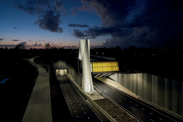
The motorway approach into the Waterview Connection’s 2.4km-long twin tunnels.

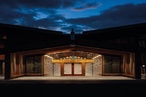
Yellow glass windows above the entrance give the impression of the inner workings of the tunnel to help reduce any anxiety about entering the tunnel.

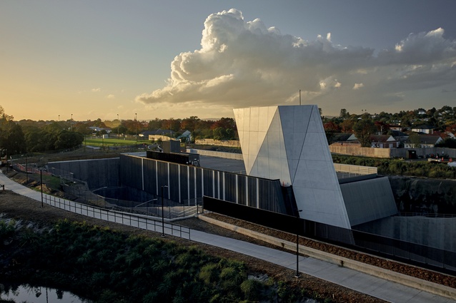
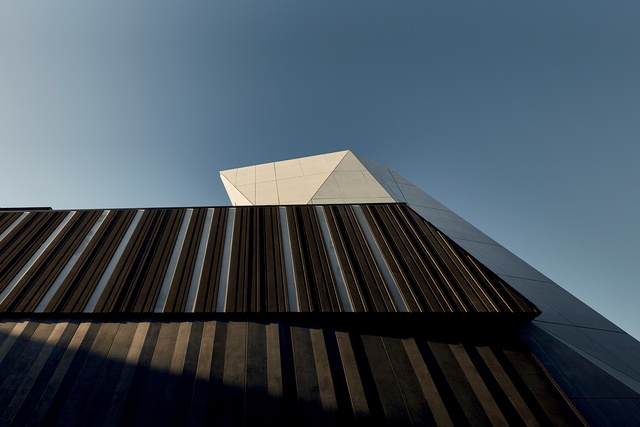
Close-up view of the ventilation stack, which alludes to the angular, faceted forms created by volcanic activity.
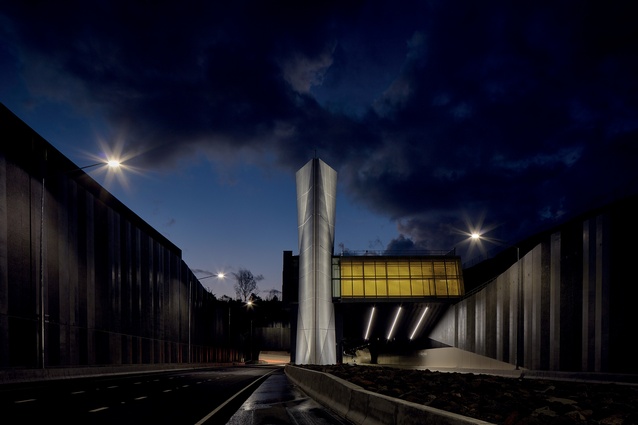
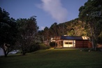
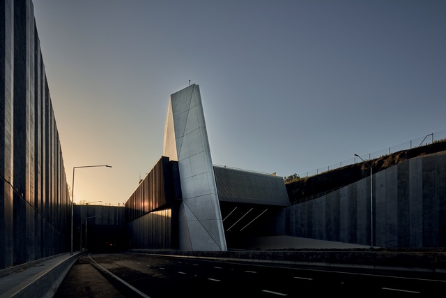
Night-time view of the southern ventilation building.

The western elevation showing the southern ventilation building.
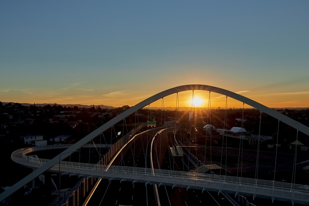
Te Whitinga pedestrian bridge spans the motorway, referencing Auckland’s maunga with three pure arcs.
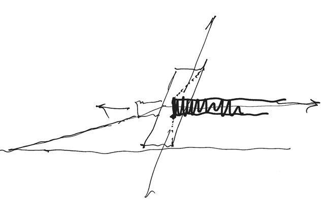
Tunnel vent sketch.
The Waterview Connection forms part of Auckland’s Western Ring Route and incorporates New Zealand’s longest road tunnels and spectacular entranceways – a collaborative design effort by architects Warren and Mahoney, and the Well-Connected Alliance, in consultation with local community groups.
Seventeen years of planning, five years of construction, 11,000 workers, $1.4 billion, 74,500m3 of aggregate, 5km of drainage pipe, 140,000m2 of paint, 50km of cable trays, 24,000 concrete segments, 4,000 lights and so on were needed to create the twin 2.4km-long tunnels known as the Waterview connection, which opened in July 2017.
While the project began to be developed in the early 2000s, the idea to connect State Highways 20 and 16 was first proposed in the mid-1950s by an American consulting firm, which was brought in to assess Auckland’s future transport needs. The idea was put on the back burner until 2011 when, finally, it was fast-tracked under the Environmental Protection Authority; then, in October 2011, the New Zealand Transport Agency (NZTA) announced that the Well-Connected Alliance would build the tunnel.
The Alliance included the NZTA, Fletcher Construction, McConnell Dowell Constructors, Parsons Brinckerhoff, Beca Infrastructure, Tonkin + Taylor and Obayashi Corporation, with Warren and Mahoney leading the design of the architectural elements and Boffa Miskell on the landscape and urban design aspects.
The scheme was not popular with everyone and there was some opposition from the Waterview community. The tunnels were, after all, to be constructed below their neighbourhood and a good number of homes along Great North Road had to be sacrificed.
However, while some community members remain steadfast in their opposition even now, many objections were turned around thanks to the community’s involvement in the project, which resulted in cleaned-up green spaces, walking tracks, a playground, a skatepark, a pump track and, inadvertently, a new school being delivered to Waterview, as well as the benefits of reduced travel times around the city.
Boffa Miskell and Warren and Mahoney have a history of working together on similar projects, along with Fletcher Construction on the Victoria Park Tunnel. The early design phase was based on a council-driven Urban Design Landscape Master Plan but this was amended and added to through consultation with a Board of Inquiry and community liaison groups, which included stakeholders and residents.
“We went through consultation periods as we were designing,” says Peter Whiting, senior landscape architect at Boffa Miskell. “We always went to meetings with concepts, rather than complete designs, because we wanted the community to have a sense of ownership of these designs. The groups offered really good advice as they knew the area and knew the users.”
Margi Watson, local councillor, community member and chairperson of Waterview Primary School, was particularly vocal in ensuring the tunnel didn’t negatively impact on her community. She says the Board of Inquiry’s decision to set consent conditions that required liaison with community groups was beneficial to all parties.
“It ensured that there were opportunities to challenge design, look for better outcomes, seek community input and deliver a construction project that is both complex and built with respect to the surrounding environment and community.”
Participants in the liaison groups were concerned about protection of heritage, environment, design and enhanced mitigation, to name a few, says Watson. “Communities have so much to offer on big infrastructure projects – they just need a voice at the table,” she says.
For Warren and Mahoney, the team approach created by the formation of the Well-Connected Alliance was integral to the success of the project. “The entire team of different disciplines came together with the common driver, which was for the project to be better than people expected it to be,” says Shannon Joe, project designer at Warren and Mahoney.
The design of the tunnel and the surrounding infrastructure and landscaping follows a theme that references the geological history of the area. The ventilation stack on the southern end of the tunnel and its younger brother, the stair egress at the northern end, allude to the angular, faceted forms created by volcanic activity. The noise walls are like columns of basalt in the colours of lava and rock. The shape of Te Whitinga, the pedestrian bridge that spans the motorway, also references Auckland’s maunga.
“The form of the arch itself is a conic section elevation, which ties in with the volcanic landscape; it is a form that isn’t foreign to people in this city,” says Tom Locke, project architect at Warren and Mahoney.

The bridge formed part of the original reference design but the architects took what they felt was strong in the design and refined it. “In a motorway environment, you don’t have a lot of time to take in things that are complex,” says Locke. “In plan, the bridge is three pure arcs. The arch structure itself is a single continuous arc that tapers and crosses the bridge diagonally. That sets up some of these nice moments you get when you’re on the bridge, where it is quite a cathedral-like space.”
Joe adds that the bridge provides a strong sense of horizontality, which contrasts nicely with the vertical connector provided by the ventilation stacks. “The original thinking was that you would see the bridge before the ventilation stack. It is a pedestrian footbridge – not for cars – so there was the opportunity for it to be a strong symbol of what the connection is about. We needed to bring a positiveaspect through infrastructure: a way to bind the community together.”
There was a large amount of community involvement in the positioning and design of the vent stack at the northern end of the tunnel. Originally, it was planned to be at the tunnel entrance but this would have placed it adjacent to Waterview Primary School. The community asked that the stack be moved to the other side of Great North Road and, in turn, there needed to be changes in the design to fit with the environment there.
“One of the key things we considered was the difference between the motorway environment, where high durability is required and everything is experienced at high speed, and the public realm, which is largely about a contextual approach, more naturalised and in the planted environment,” explains Locke.
“When the stack was moved across the road into the landscape and the public realm, instead of doing the formed shard aesthetic, we took the approach of doing something softer. This was a long process with lots of iterations and key drivers that came from community consultation.”
The stack was required to be exactly 15m tall and needed to have an open diameter of 60m, which was a squat shape to work with. The architects leaned it away from the road so that it didn’t cast too much shadow and created screens of steel that reference the striations of forms such as obsidian. The height of the screens rises above the 15m limit but, through consultation with the community groups, it was decided that this was necessary and permission was granted.
The experience of going underground is fraught with anxiety for some and this was taken into account in the design of the buildings at the tunnel entrances. Yellow glass windows above each entrance give the impression of the inner workings of the tunnel. “Boffa Miskell and ourselves dealt with the local, contextual and personal responses to the infrastructure,” explains Locke.
“That was a major driver behind the glass boxes at both portal entries. At the very least, you get the impression that you are not just entering into an underground world but that there are systems looking after you.”
Other than the stacks and the tunnel entrances, there is not much outward appearance of buildings in the Waterview Connection, as most of the ventilation and electrical equipment has been recessed underground. This allows the more beautiful aspects of the project to shine through.

The ecology of Te Auaunga (Oakley Creek) was improved through realignment work carried out by Boffa Miskell. The creek previously flowed through a rock-lined channel, a product of the work of 1930s’ depression workers. “It had no ecological habitats at all,” says Pete Whiting. “Realigning it has totally enhanced the stream format and put it back into naturalised channels. It has allowed it to pool in some areas and ripple in others. This created a much healthier stream environment.”
Artwork and sculptural gestures relate to the stories of the area’s iwi, Ngāti Whātua Ōrākei. At the southern portal, artist Graham Tipene created concrete panels that depict the legend of Hinemairangi and Tamareia, a couple who eloped and escaped capture by travelling along the Manukau Harbour under the feet of Ōwairaka (Mt Albert) and the Meola Reef.
Steel-cut screens around the pier legs at the Great North Road interchange were also created by Tipene and by fellow artist Te Warena Taua Junior of Te Kawerau a Maki. These are particularly effective at night when they are backlit.
“Hopefully, the project has made a substantial yet subtle impact on Auckland,” says Shannon Joe. “We hope it merges with the surrounding fabric of good things and becomes influential to all future infrastructure jobs.”