A short history of the sixties downtown
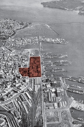
Downtown Auckland.

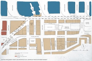
Existing development streets and properties plan.
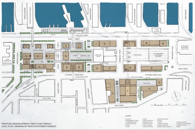
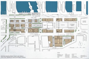
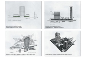
Proposed redevelopment streets and terrace level plan.
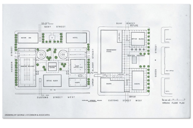
Drawing by George J O’Connor & Associates.
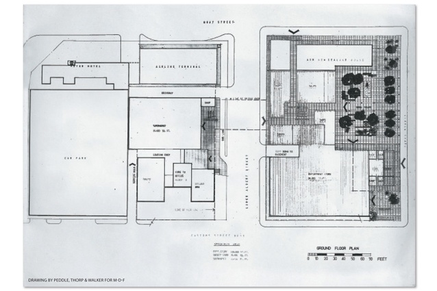
Drawing by Peddle, Thorp & Walker for M-D-F.
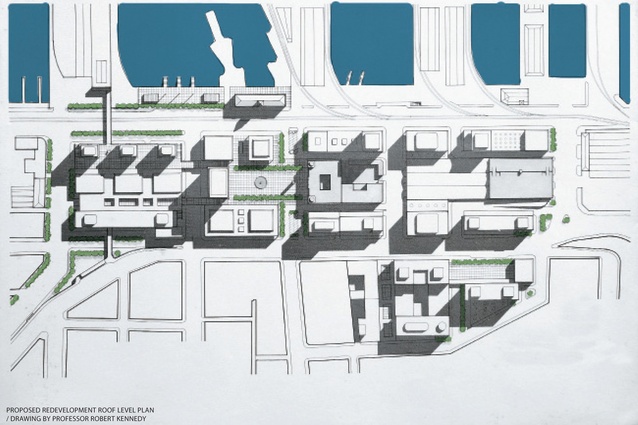
Proposed redevelopment roof level plan.
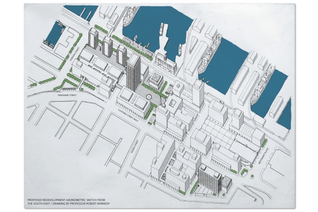
Proposed redevelopment axonometric sketch from the south-east.
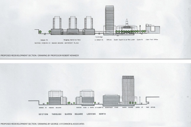
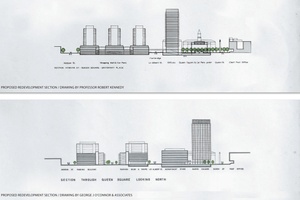
Proposed redevelopment sections by professor Robert Kennedy (top) and George J O’Connor & Associates.
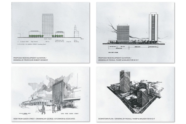
Proposed options for Downtown redevelopment by professor Robert Kennedy (top left), George J O’Connor & Associates (bottom left) and Peddle, Thorp & Walker for M-D-F (top and bottom right).
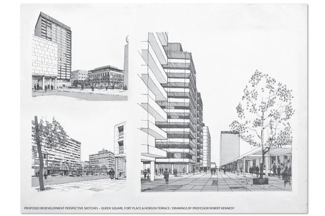
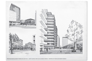
Proposed redevelopment perspective sketches - Queen Square, Fort Place & Hobson Terrace.
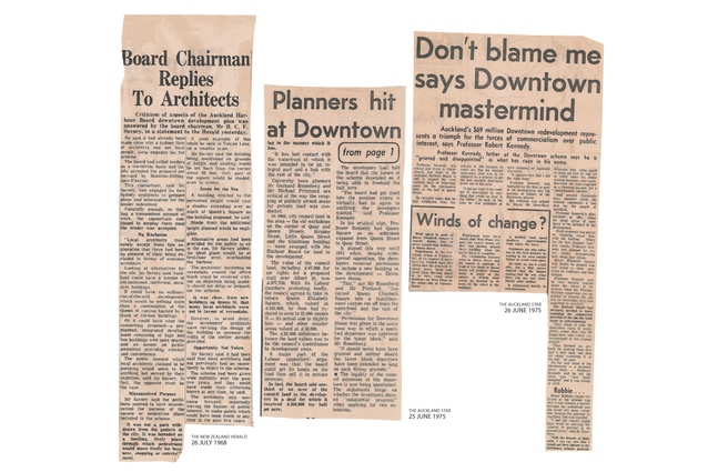
Newspaper clippings.
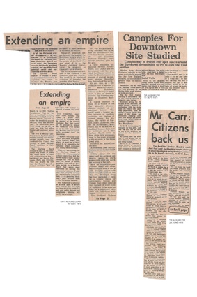
Newspaper clippings.
Dennis E Smith B Arch FNZIA takes us down memory lane, nearly 60 years after the sequence of events that determined the shape of a significant part of Auckland's Downtown. You might conclude that the process was a form of architectural Chinese whispers.
- This article first appeared in ArchitectureNZ, issue 2.2013.
From its establishment in 1871 until its dissolution by the Port Companies Act 1988 as part of the local body reorganisation, the Auckland Harbour Board (AHB) owned the bed of the Waitemata Harbour: some 2,000 hectares, of which 160 had been reclaimed, including the Downtown area from Fort Street to the present waterfront. Only a part of this land was needed for port purposes; much of the remainder was developed for retail and commercial uses over the period 1880 to 1915. Over the years, the annual rental provided significant income for the Board and it was not only used to even out fluctuations in shipping revenue, which varied according to rises and falls in the New Zealand economy, but also to keep wharf charges competitive relative to other ports. However, by the early 1960s, as the buildings deteriorated and retail and commercial practices changed and air-conditioned multi-storeyed offices, such as the AMP Building, started to appear within the neighbouring Auckland City Council (ACC) jurisdiction, the Board decided that some form of renewal would be needed to maintain its income from this part of its landholding.
Enter Professor Kennedy. Robert Terence Kennedy trained as an architect in Manchester and worked in the office of (later Sir) William Holford before joining the new Ministry of Town & Country Planning, working on the reconstruction of war-damaged English towns and the new town development programme. In 1951, he was awarded a CBE for this work. He resigned from the Ministry in 1955 and had a short stint as a consultant to Holford before coming to New Zealand in 1957 to head the newly established School of Town Planning at The University of Auckland.
In 1963, Kennedy was engaged by the AHB to assist with this renewal process. The study site was bounded by Quay Street, Britomart Place, Fort Street, Customs Street East and Hobson Street: a total of 13 hectares of which, excluding streets, the AHB owned 5 hectares, the Crown 0.5 and ACC 1. The Commercial zoning of the land stipulated 33.5m maximum building height and maximum 10:1 FAR (ratio of building floor area to site area). There were no specific car-parking requirements but a survey of the study area at the time found 920 spaces, including 465 in the Britomart Car Park building. In a broader context, the metropolitan population was 500,000 and there was no reliable data on projected CBD building or traffic growth.
In January 1964, Kennedy introduced his completed report1 by saying that it addressed the Board’s wish to develop a long-term view for the area as a whole (rather than proceeding with uncoordinated “exploitation” of individual sites) and that it would help the Board clarify its estate policy for the potential redevelopment and thus promote investor confidence and the public interest.
He stated that he had tried to balance the foreseeable demand for building bulk and floor space for different uses with “the very frequently expressed desire that Quay Street and the beginning of Queen Street should present a well-planned and worthy entrance to New Zealand’s largest city”. The proposed Queen Square would be a place of civic importance – “a location worthy of the best the country can produce in fine buildings”. And more generally, he said that his proposals endeavoured to rebuild to a pattern and scale appropriate to present-day requirements, to improve pedestrian and vehicular circulation paths and to enhance the environment for those working in or visiting the area.
The accompanying drawings, prepared by Professor Kennedy’s son Nicholas, show an arrangement of shops and offices. One group is centred on Queen Square and incorporates a conference hall on the axis of the Ferry Building (and of similar height) and an underpass to it. A second group to the west of Albert Street is centred on a podium and includes three apartment towers – a departure from the Commercial zone that he felt was warranted given the location and views. The podium, which has bridge connections to the Princes Wharf passenger terminal and across Albert Street, has three floors of car parking – 480 spaces – below. A further mixed-use development was proposed between Fort and Customs Street East.
The proposals provide for the staged construction of 260,000m2 of new floor space: less than the 540,000m2 that would have been created by applying the 10:1 FAR over the entire site and which was judged to be too high given the limitations of the existing roading pattern to handle goods, pedestrian and vehicular traffic. The 260,000m2 broke down into 43,000m2 for retail, department store and bank uses, 187,000m2 of offices, 16,000m2 of hotel accommodation, 12,000m2 of residential accommodation and the conference hall of 1,900m2. In addition to the 465 car-park spaces in Britomart, the scheme provided a further 690, 28 of which were short-term spaces associated with the post office, and which might be regarded as creating an anti-climactic termination to the Queen Street corridor.
On their release by the Auckland Harbour Board, Professor Kennedy’s proposals received extensive positive publicity in The New Zealand Herald, The Auckland Star and other publications. The two newspapers reproduced the principal drawings and either paraphrased his report or quoted it verbatim. Mayor Dove-Meyer Robinson described the scheme as “exhilarating” and various other interest groups, such as the forerunner to Heart of the City, were supportive.
The report noted that, to advance the proposals, more detailed financial and legal studies would be necessary and that is exactly what happened next.
Enter George J Connor & Associates (Connor). In early 1964, the Harbour Board engaged the Melbourne-based property consultant Connor to review the “outline redevelopment scheme” prepared by Professor Kennedy. Connor was asked to focus largely on the area bounded by Queen, Quay, Hobson and Customs Streets and to report on its development potential, economic feasibility and marketability, and to offer an opinion regarding any changes to be made to Kennedy’s proposals to improve their economic soundness and civic and commercial attractiveness. Further, Connor was to advise on the form of development best suited to the circumstances, provide an economic analysis, and suggest an implementation plan.
Connor reported back in June 1964.2 The first section of the report describes a survey of existing transport patterns, property values and rentals, and the market for office space, large and small retail, apartments, hotels and car parking. There were several significant conclusions made from this preliminary work. The survey found 5,000 car-parking spaces – 3,000 public – within walking distance. Connor considered about 10,000 would be needed, 1,500 of which could be accommodated on the study site. There was agreement with Kennedy that the proposed elevated road above Quay Street would seriously detract from the development potential of the site, and that the eastern part of the study area should be seen as a long-term prospect, given the more complex nature of land ownership there. Regarding actual buildings, the report observed that the expansion potential of the existing Queen Street department stores, Smith & Caughey, John Courts and Milne & Choyce was hampered by site constraints, and something more in line with their larger, more glamorous Sydney or Melbourne counterparts should be considered. From Kennedy’s report and plans, Connor calculated that an unachievable weekly rental of $27.30 would be required for each apartment and subsequently that this was not a viable use. The podium was also viewed unfavourably.
Connor recommended that the block bounded by Queen, Quay, Albert and Customs Streets (Block A) should be intensively developed for retail uses, to act as a catalyst for the future development of the remainder of the site. By building 50 per cent more floor space than Kennedy had proposed for this area, Connor calculated that the Board’s potential rental income would increase from around $820,000 per annum to $1,430,000. It would be a practical proposition within the next few years if approached in two stages.
Stage 1 would comprise a major department store, a 22-storeyed office tower and, in the block further to the west (Block B), two car-parking buildings, each with a capacity of 700–800 cars and designed for future vertical expansion. Stage 2 could feature another office building, an hotel and a conference facility.
These proposals are shown in the report’s schematic drawings. Notable features include the lack of formal recognition of the Ferry Building given the location and scale of the office block, the overshadowing of Queen Square over the busy midday period by the office block, the shortcomings of Queen Square as a civic space and the dominance of the outdoor spaces of Block B by the car-parking facilities.
In January 1965, the Board resolved to advance the project by developing a prospectus – essentially a tender request document – with the help of Kennedy and Connor, and employing an advertising agency to give it some gloss. The resulting prospectus3 was in two parts: Part 1 was prefaced by the AHB chairman describing the project as a unique opportunity, having the potential to give adequate recognition to the aesthetic linking of the port and the city. It covered the contractual aspects including the lease of the land during the construction phase and for the following 105 years. Ground rental for the first 21 years post-construction was set at $300,000 per annum.
Part 2 included, amongst other background information, a surveyor’s drawings, bore logs and Kennedy’s and Connor’s drawings. The stated desired outcome was, however, closely aligned with Connor’s recommendations, stipulating for the eastern Block A a 61,000m2 department store plus specialty shops and an office tower of 76,000m2, together with “generous and handsome” open spaces, including a square of 9,000m2 in front of the post office.
The western Block B was to accommodate shops and offices, parking for 1,000–1,500 cars, a conference centre and tourist facilities. In adopting these figures, the AHB effectively sidelined Kennedy’s scheme.
The project was then widely advertised in New Zealand, Australia, the USA and the UK, resulting in the issue of 406 copies of Part 1 of the prospectus and 122 copies of Part 2. Privately, the Board must have been very disappointed with the outcome. Two offers from UK property companies were so insubstantial that they were immediately written off. The only other offer was from a consortium comprising Mainline Construction Pty Ltd, an Australian subsidiary of a US contractor, Dillingham Constructions Pty Ltd, an Australian subsidiary of a Hawaiian firm, and Fletcher Trust & Investment Co Ltd (M-D-F). In a covering letter dated 28 January 1966, the consortium expressed an interest in the project but regretted than it could not offer a complying tender.
Publicly, the Board chairman, Mr RCF Savory, talked up the results. Tenders were “of a wonderfully high standard… the models and plans I have been looking at are really wonderful”.4 The scheme was “the most important thing to happen to Auckland since the city was founded by Captain Hobson in 1840”.5
The M-D-F tender submission outlines the consortium’s investigation of the project. Apart from sounding out views of central, regional and local government, and seeking retail planning, financial and legal advice, it also engaged Sydney architects Peddle, Thorp & Walker to translate the conclusions it had reached into architectural form. The offer recorded a number of points. Firstly, as far as M-D-F could establish, no major retailer in New Zealand or Australia was willing to commit to establish the proposed department store and, without this feature, the viability of smaller retail uses was questionable. Further, car-parking buildings were not attractive investments but, possibly, Auckland City might like to lease any facilities that were included in the development. Queen Square was “a total loss from an investment point of view”: the developer would pay the construction costs, and an annual land rent without receiving any revenue. However M-D-F anticipated that, notwithstanding the surplus of office space in Auckland at the time, the first office block would, given its attractive location, attract sufficient demand and could be commenced at an early date. The Harbour Board had signalled its intention of relocating its offices there and there were other interested parties, including Air New Zealand. A motor hotel and airline terminal were suggested as possible additions to the development, and a second office tower noted as “an essential complement to the scheme” after the other buildings were completed and occupied. The offer was conditional on a number of requirements including the relaxation of the height limit, granting of residential use in the Commercial zone for the motor hotel, the closing of Little Queen and Sturdee Streets at no cost to the consortium and no elevated road above Quay Street.
Additionally, M-D-F was not willing to take a head lease of any of the major buildings, given “the New Zealand economic climate”, and therefore envisaged that they would be owned by a Life Office – code for the AMP Society, which wanted to stay in the background at this point. The offer recorded that the Life Office had a strong preference for freehold title to the land.
The accompanying drawings show, for Block A, an elongated office block taking up most of the frontage along Quay Street, a second office block more or less opposite the post office, and the department store and smaller shops fronting Customs and Albert Streets. The north-west of Block B is taken up with a motor hotel with a large car-parking building to its south. The east side of the block accommodates, from north to south, an airline terminal, supermarket and an office block. To link the two blocks, a wide bridge with shops was proposed across Albert Street. The architects wrote: “The buildings are set back from the streets, varied in height and staggered on plan to avoid the appearance of a solid wall from the harbour and the city beyond” and that “shading effects have been carefully studied and high-rise buildings have been placed so that buildings in and adjacent to the scheme obtain the greatest benefit from free air circulation and direct sunlight”.
The opinions of both Kennedy and Connor were sought. The former’s comments were directed largely at the conditions attached to the offer and in refuting some of its assertions. He stated, however, that the design showed a high degree of planning competence on the part of the architects and that the scheme was technically feasible. This appraisal would later be used by the Board to counter criticism from local architects. Having described the design as attractive, Connor principally addressed the effect that the staged development would have on the Board’s land rent revenue and the complications that freeholding part of the site would introduce. Both advisers were of the view that the consortium’s building cost estimates were high and that this might have been done to show that its net return on the project was low.
Negotiations between the AHB and M-D-F resulted in AHB concessions regarding ground rentals and lease terms, and things proceeded to the point that, in April 1966, a draft agreement prepared by Board officers had received formal Board approval and finalisation and execution was imminent. In preparation, the Board had spent about $2 million buying out the leases of affected tenants, so as to present the consortium with an unencumbered site. But in July, M-D-F advised the Board that the AMP Society would not finance the project unless at least part of the site was freeholded.
Over the next few months, the AHB reflected on its options: maintain its leasehold policy and have M-D-F walk away; invite fresh tenders – probably pointless; agree to the consortium’s terms; sell the entire redevelopment area; construct and promote buildings itself; defer the project; and several other financial/land tenure possibilities that might have suited the consortium.6
The outcome was that in November it decided that a further small concession could be made, if that was what was needed to make progress, and the relatively small building footprint needed by the Quay Street office building could be free-holded, given that the remainder of the Stage 1 land would remain in leasehold tenure. As the land was effectively publicly owned, legislation was needed to formalise this transfer and, although this process took until October 1967, the Board’s decision cleared the way for the consortium to proceed.
With Stage 1 funding settled, the scheme was formally submitted to the Auckland City Council in June 1966. In a report of 27 July, Mr AJ Dickson, director of Works and City Engineer, briefed councillors on planning aspects, noting significant departures from the planning ordinances in respect of building height and the 65° height plane, but also that the FAR was about 50 per cent of the allowable, and that there were numerous public spaces and setbacks. He stated that the placement of Office Block 1 (1 Queen Street) “gives occasion for some concern because the shadow of this building will have a detrimental effect on the public enjoyment of the square”. Council studies had shown that, at the equinoxes, the square would be almost completely in shadow from 11.00am until 1.30pm and, at the winter solstice, from 10am until 2pm. Dickson advised that the developer’s attention should be drawn to this with the suggestion that consideration be given to ameliorating the situation, to provide a greater degree of public enjoyment of a “singularly important public square”.
A few months earlier, M-D-F had outlined the scope and staging of the development proposals to the long-forgotten building programmer at the Ministry of Works. His role involved not only advising on the programming of government works but also setting priorities for the building and construction industry as a whole. His approval was necessary for any project over a certain value to proceed and his response in July 1966 in respect of the Downtown project was, “Building resources in the Auckland area for urgent major construction works are of such magnitude and priority in the public interest that it is necessary to defer a substantial volume of less-important work”. M-D-F was advised to come back in a year’s time. This issue and delays in closing Little Queen Street impacted on the building programme, which was adjusted to show the hotel and car park starting construction in March and August 1968, respectively, and the Quay Street office building in March 1969.
On 19 June 1968, two years after the initial presentation to Council, its Town Planning Committee granted M-D-F a dispensation from Council bulk and location requirements and, the very next day, issued a press release to the effect that public objection rights were not taken away.7 This was in response to criticism of the process by Mr V Youl, then Chairman of the NZIA Auckland Branch. The prospect of objections raised concerns within the AHB. Mr Savory claimed that the redevelopment might be delayed for months if any objections were lodged, adding that he had held discussions with the Institute and with School of Architecture students and he was “still hopeful that common sense would prevail”.8 Mr Savory also met with the Auckland Architectural Association. A day after these discussions, he announced that the project architects had been instructed to increase the width of the ground floor colonnades on Office Block 1 to improve pedestrian cover, thus removing one potential point of objection.9 Auckland mayor, Dr McElroy, supported the AHB, saying that any delay would be a “serious blow to the city”. And the Master Builders Association agreed with these sentiments.
Objections were lodged by the Auckland Branch of the NZIA and the Auckland Architectural Association after Special Meetings of both organisations had been called, and also by a number of individual architects. In summary, the grounds included loss of amenity resulting from excessive overshadowing and loss of sunlight to the square and other streets, and from excessive wind movement created in the vicinity of the tall buildings, together with non-compliance with town planning ordinances and “sound contemporary urban design principles”.
The Board’s response is recorded in a statement given to The New Zealand Herald on 26 July.9 It implied that local architects were suffering from sour grapes because Sydney architects had been chosen by the consortium and stated that their objections were actually contrary to the public interest, that they had misconceived the nature of the square, which was not a “withdrawn park” but instead a “bustling, lively place through which pedestrians would move freely for business, shopping or entertainment”, that the Board could have addressed the verandah issue outside the objection process, that even if Office Block 1 had complied with the 33.5m height ordinance it would still have overshadowed the square and the effect of the additional 35m height was negligible and, finally, that details of the proposals had been available for two years and that “architects waving the banner of public interest” could have expressed their views at any time in that period.
Objections were heard by Council’s Town Planning Committee on 13 August 1968. The NZIA had withdrawn its objection 12 days earlier, citing a firm undertaking from the developers to address the issue of cover for pedestrians. Notwithstanding this change of heart, the Institute continued to publicise its misgivings about the bulk and location of Office Block 1.
At the conclusion of the hearing, the objectors were thanked for the thoroughness of their submissions and, on 15 August, the application was approved. The committee ruled that there was insufficient evidence to warrant any changes, particularly as any reductions might mean the abandonment of the scheme. By 1973, Office Block 1, the low airline terminal block, the car-parking building and the hotel had been built.
Construction of Office Block 3 (Quay Tower) was due to start in 1975. The Architectural Association again raised the issue of the building’s non-compliance with the planning ordinances, on the grounds that the resource consent had expired and no progress had been made. This argument was rejected by the Council but the publicity prompted more debate.
In June 1975, The Auckland Star published a series of articles as part of what it called an investigation into the success or failure of the Downtown scheme. Professor Kennedy, who had moved to Christchurch on his retirement in 1969, said that he was “grieved and disappointed” by what had arisen in his name and that short-term commercial interests had been the main factor in the development. The mayor (now Sir) Dove-Myer Robinson, back for a further term, after pointing out that he was out of office when major scheme decisions were made, said the Council “may have erred” in allowing the scheme to proceed as “it had lost contact with the waterfront of which it was intended to be an integral part and a link with the rest of the city” and that it was a “near disaster socially”.10 Comment from staff of the School of Town Planning was also reported, together with claims that wind speeds in parts of the square were double those in Queen Street.
These views were refuted by Mr RW Carr, AHB chairman following the retirement of (now Sir) Reginald Savory in 1971. He claimed that most Aucklanders supported the development, adding, “Too much of the criticism… seems to be incited by academics with town-planning theories and the lingering resentment of some local architects…” He accused Kennedy of adding to the slander of the Board and its other advisers. Sir Dove-Myer was told he should be grateful as the development represented a rating bonanza for the Council.11
In September 1975, The New Zealand Herald reported that AMP, its architect and The University of Auckland School of Engineering were working together to analyse and remedy the wind problems that had arisen.12
To which view of history do you subscribe? The 1981 Neil Finn/Split Enz version (History Never Repeats) or the 1905 George Santayana one (Those who cannot remember the past are condemned to repeat it).
- Thanks to Marleene Boyd - librarian, Voyager New Zealand Maritime Museum. Also to Wendy Garvey - librarian, The University of Auckland School of Architecture Library and staff at the Auckland City Council Archives.
- Monetary figures are a 1960s values and have been converted on the basis that £1 = $2. Imperial measurements have been converted to metric, with some rounding.
Footnotes:
1. Kennedy, Professor RT: Auckland Harbour Board - Auckland Central Area Properties: Report and Development Plan. January 1964
2. O’Connor, George; George J O’Connor & Associates: Auckland Harbour Board - Redevelopment Plan, Central Area Properties: Economic Analysis & Feasibility Report. June 1964
3. Auckland Harbour Board Archives. Voyager NZ Maritime Museum, Auckland Harbour Board: Invitation to Tender for Central Area Properties Redevelopment Scheme, Stage 1 - Prospectus Pts 1 & 2. April 1965
4. NZ Herald; 29 January 1966
5. NZ Hearld; 24 April 166
6. Auckland Harbour Board Archives. Voyager NZ Maritime Museum; File 59/2/8 Pt 2, SN143. 7 October 1966
7. Auckland Star; 20 June 1968
8. NZ Herald; 24 July 1968
9. NZ Herald; 26 July 1968
10. Auckland Star; 26 June 1975
11. Ibid
12 The New Zealand Herald; 11 September 1975