Conserving memory and culture through virtual reality design
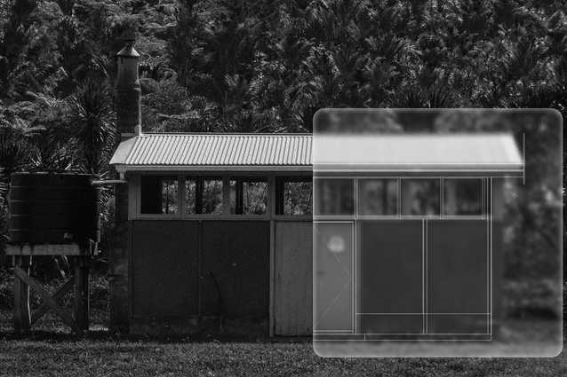
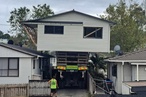
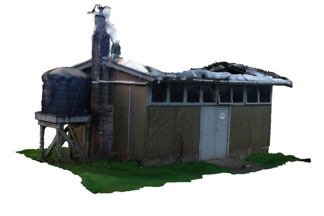
Image of Nigel Hanlon Memorial Hut Modified by Devarsh M Patel, Courtesy of Stefan Marks.
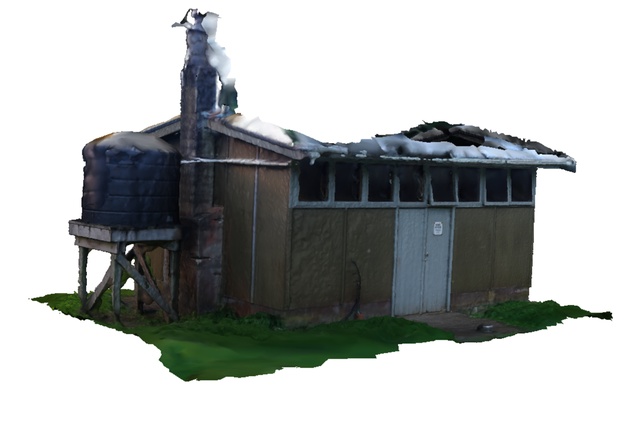
Textured Model in Agisoft Metashape, by Devarsh M Patel

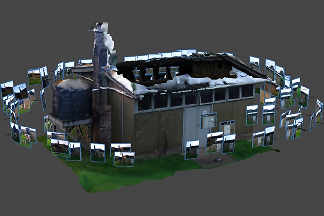
Camera and Image Alignment Model in Agisoft Metashape, by Devarsh M Patel
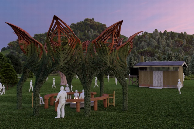
Campfire Folly in Context, by Devarsh M Patel

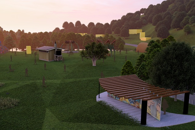
Proposed Proof of Workflow Render, by Devarsh M Patel
Research from Auckland University of Technology explores how photogrammetry and virtual reality support hybrid workflows for conserving at-risk cultural heritage.
Contemporary challenges: Natural hazards, climate change, and beyond
In Aotearoa New Zealand, living with the challenges posed by multiple natural hazards is not new. Earthquakes, floods, and fire have shaped the development of our neighbourhoods and cities, while many of these risks are also exacerbated by climate change. Globally, communities face similar challenges, alongside the need to develop resilient and sustainable approaches to urban transformation that draw on existing buildings and place-based knowledge.
At first glance, the intersection of rapidly evolving digital technologies such as Artificial Intelligence and the centuries-old nature of cultural heritage may appear contradictory. Yet both act as dynamic platforms through which individuals and communities express shared values. Increasingly, digital technologies are being applied for the conservation of cultural heritage in all its forms, from art, language, and historic buildings and landscapes. This article shares lessons from research conducted in 2024–2025 that investigated the use of Virtual Reality (VR) to develop a hybrid workflow for documenting and designing interventions for at-risk cultural heritage sites.
Integrating digital technologies for a hybrid ‘Documentation To Design’ workflow
Sir Edmund Hillary’s Antarctic Hut at Scott Base demonstrates how photogrammetry and VR can provide immersive access to remote and environmentally fragile heritage sites. Closer to home, the recent HBIM-based documentation of Unitec’s Building One illustrates how these tools can support the recording of locally significant buildings under threat.
Inspired by these precedents, the project developed a four-step workflow combining photogrammetry, Heritage Building Information Modelling (HBIM), and VR. Photogrammetry generates three-dimensional models from overlapping photographs, while HBIM adapts Building Information Modelling for the documentation, conservation, and management of historic places.
A site located within the Waitākere Ranges in West Auckland was selected as a case study for testing our proposed workflow. Constructed in the 1950s, the small timber-framed Nigel Hanlon Memorial Hut based at Piha has supported outdoor education and community use for decades. Set within a dramatic coastal landscape, it is increasingly vulnerable to flooding, vandalism, and environmental degradation, risks expected to intensify with climate change.
The hut’s existing condition was documented through an on-site photographic survey using an Android smartphone. Images were processed in Agisoft Metashape, software to convert overlapping images into accurate three-dimensional digital models, producing a point cloud and a textured 3D mesh, and capturing surface conditions, material weathering, and construction details. These attributes were linked to spatial and environmental data within the HBIM environment.
The textured model was imported into Shapelab VR to correct photogrammetric artefacts, including point cloud ‘noise’ and surface irregularities. Working at full scale within VR enabled intuitive interaction with the model, improving spatial understanding and allowing inaccuracies to be resolved more efficiently than in conventional screen-based workflows.
Using the masking tool in Shapelab VR by Devarsh M Patel
The refined model was then positioned using Autodesk Revit to accurately situate the hut within its landscape, before being reintroduced into Shapelab VR.
Within VR, speculative architectural “follies” were explored - bridging physical documentation with digital design, enabling accurate recording and creative 3D sketching and modelling.
Using the smoothing tool in Shapelab VR by Devarsh M Patel
Benefits of an integrated ‘Documentation to Design’ workflow
Beyond capturing tangible heritage attributes, this workflow supports the representation of intangible heritage, including memories, cultural practices, and user experiences. Advantages include high visual accuracy, accessibility through easily accessible consumer-grade cameras available on most smartphone devices and VR headsets. This approach aligns with recommendations from CARE (Collective Benefit, Authority to Control, Responsibility, Ethics) and FAIR (Findable, Accessible, Interoperable, Reusable) principles, and the ICOMOS New Zealand Charter for the Conservation of Places of Cultural Heritage Value (2010).

Current technological limitations
Photogrammetry is sensitive to lighting conditions and surface reflectivity, affecting accuracy. Without LiDAR or drone imagery, certain site elements such as the roof could not be captured to the same level of detail. VR integration is also hardware dependent, limiting accessibility for wider community engagement, and processing large datasets can be time-consuming on standard computers.
Next steps
VR enables real-time exploration of spatial qualities and proposed interventions, enhancing communication and collaborative decision-making. With increased engagement within the VR community and as immersive technologies evolve, Augmented Reality is emerging as a natural next step in enhancing immersive experiences.
During 2024-2025, we contributed to the development of the UNESCO Chair in Digital Twins for World Heritage Conservation led by Carleton University, Canada, and the Universidad del Azuay, Ecuador. In 2026, we plan to expand this work to explore the potential of emerging digital technologies for inclusive storytelling and culture-based climate action.
The complete render video can be found here.