Mr Ward’s Map: Victorian Wellington street by street
Robin Skinner reviews Elizabeth Cox’s impressive new book, which documents the c. 1900 edition of surveyor Thomas Ward’s map of Wellington with accompanying commentary.
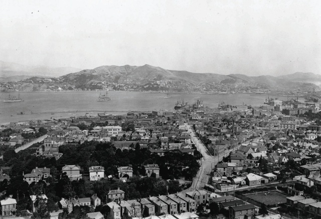
It was a remarkable proposal. In 1889, the surveyor Thomas Ward offered to produce a large-scale map of Wellington for the city’s council. Two and a half years later, he submitted 88 sheets documenting an area from Thorndon in the north to Berhampore in the south, taking in Newtown, Mount Victoria, Te Aro, The Terrace and the city centre. At a scale of 1:480, footprints of every commercial enterprise, government building, school, church and synagogue, house, shed and outhouse were included. The detail was astounding. In a project which may be without compare, Ward recorded each building’s shape, marking bay windows and verandahs, the number of rooms and storeys, and wall and roof materials. Street widths and elevations, along with positions of streetlights and fire brigade water supply points were marked. Such value was found in his work that he was commissioned to amend the sheets through the remainder of the decade.
In this impressive publication, befitting the magnitude of the surveyor’s original effort, Elizabeth Cox has documented the c. 1900 edition of the maps with accompanying commentary. Following an introduction backgrounding the surveyor, the charts, the city’s development and the context of the 1890s, some 48 chapters track through the sheets, north-to-south, discussing each area’s development, the buildings, its people and incidents that can be linked to the full-page charts. This is enhanced by well-selected (and often unfamiliar) illustrations and interpretation, yielding an expansive, thoroughly readable social history.
For those who are interested in New Zealand towns, Cox’s volume confirms Wellington to be a “shaky metropolis of matchboxes”, as a northern newspaper once disparagingly described the capital. The emergence of the villa tradition, so characteristic of many New Zealand towns, is clearly documented in the sheets illustrating the southern suburbs. And it’s easy to envisage the book becoming a go-to resource in many architects’ offices as an aid to understanding, interpretating and explaining the 1890s’ context of many ongoing projects in Wellington and beyond.
For those who enjoy maps, this book will be difficult to resist, with every chapter offering a new cartographic scenario. For others, who find maps and plans somewhat difficult, the book’s layout graphically links photographs to map details, providing a way to appreciate the detail Ward recorded. The design is exceptionally good, and the designer, Jo Bailey, is to be congratulated for unobtrusively communicating much information. Unassuming marginal footnotes reduce the need to flick through extra pages as the reader works between the map sheet and text. Well done Massey University Press.
The impact of colonisation becomes clear. By 1890, the number of Māori living in Wellington had dropped significantly since the 1830s, when Te Whanganui-a-Tara was surrounded by numerous pā and kāinga. Cox documents the loss of Māori land and alienation through successive decades across the city, providing valuable references for readers wanting to know more about this little-understood past. The maps have also enabled her to identify how Māori ownership and occupation at the Te Aro and Pipitea Pā continued into the final decade of the 19th century.
It seems to me that the legacy of the New Zealand Company’s poorly envisaged settlement becomes clearly apparent through Ward’s maps. Laying out the required 1100 town acres on difficult, sometimes steep or swampy terrain in 1840, bereft of playing fields, with piecemeal development that left whole acres vacant five decades later, and where intermediate streets had been inserted in an often ad hoc manner generated a messy layout with problematic infrastructure, which created a need for order and coherence that Ward’s project was aimed to facilitate. Repercussions from William Mein Smith’s 1840 layout continue.
At about the time the first sheet was produced, a British doctor described Wellington’s population as being largely constituted of “civil servants, insurance and bank clerks, steamship companies’ officials, and retired ex-officials”. Establishing that this was far from reality, Cox documents a community of diverse ethnicities, social orders and activities. It was a city of “the haves” and “the have nots”, of Thorndon and Te Aro, and there was excruciating poverty. However, in the decade that heralded universal suffrage, the varied experience of women described will dispel many clichés. As histories of Wellington’s Chinese and Jewish communities become increasingly well known, Cox enriches this understanding with accounts of individuals and families. And there is much that will be new. How many know of the middle-eastern businesses raided in 1897, or of the opposition to the Mount Cook gaol, or of the “multitude of suffering” associated with the industrial schools? And there’s scandals too…
Cox’s book will provoke much new work, and interest will be far-reaching. People wanting to know of urbanism in a settler colony, about a family’s past, of neighbourhoods or communities, and writers seeking a fresh canvas upon which to conjure, will find this book a valuable source. It adds a new layer to our understanding, which will deliver for decades to come.
Available from Massey University press $90
About the author: Elizabeth Cox is a Wellington historian who specialises in New Zealand’s social and architectural history.