Atmospheric submersion
Severe weather is going to come in waves, so what can architects and planners do to prepare for it?
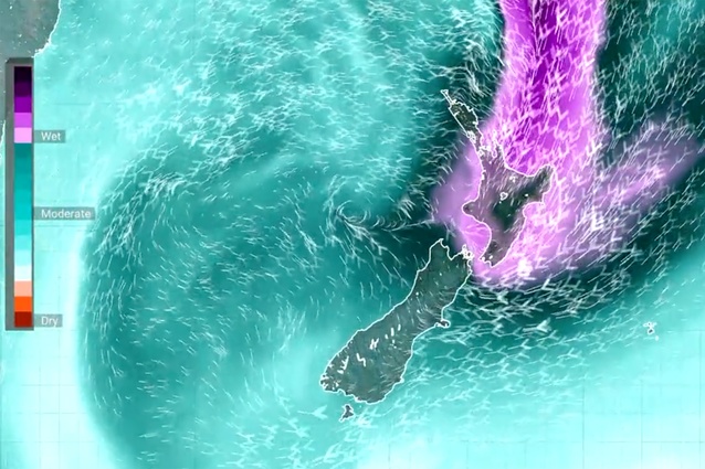
An atmospheric river as seen over New Zealand in July 2022. The purple areas indicate high moisture values associated with flooding risk.
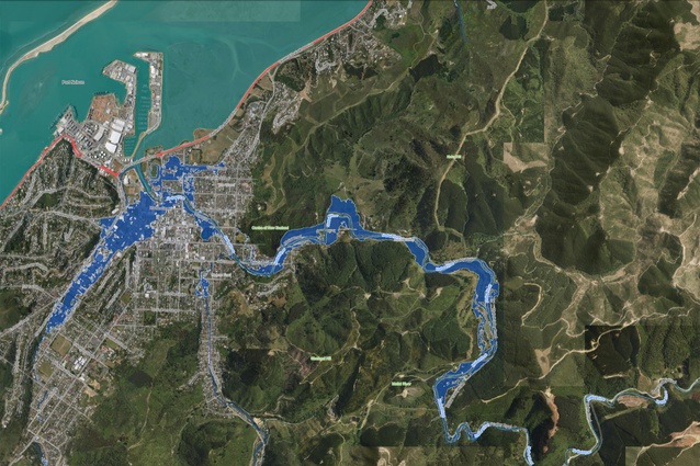
Map showing present day flooding zones in Nelson.

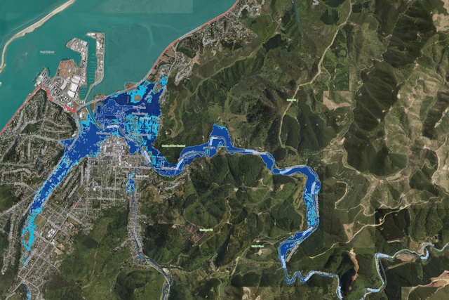
Map showing predicted future flooding zones up to the year 2130 in Nelson.
Chris Barton considers the awesome forces of nature, heightened by the climate crisis, and looks for our plans to adapt in the latest editorial for Architecture New Zealand magazine.
By now, much of Aotearoa New Zealand knows what a ‘long-lived atmospheric river’ is and just how much devastation one can wreak, especially when it parks overhead for several days.
One landed on our shores on 16 August. As NIWA meteorologist Tristan Meyers explained, atmospheric rivers are huge plumes of moisture that move from the tropics to the mid-latitudes. When such a river hits another weather event or encounters New Zealand’s mountainous terrain, vast amounts of water vapour are “squeezed” out, falling as heavy rain or snow. In this instance, the plume squeezed out torrential rain, well over a month’s worth, over four days.
What is unusual, exceptional perhaps, says NIWA, is the amount of moisture in the atmosphere – “unprecedented for August in climatological data going back to 1959”. Generally, atmospheric river activity peaks during summer and is quietest during the winter. The event is also notable for how the atmospheric river parked overhead because a blocking high-pressure system to the east of the country caused it to linger longer than usual.

A State of Emergency was declared in Nelson-Tasman, West Coast and Marlborough regions, with widespread flooding also in Northland. Nelson was hardest hit – by the end of the week, some parts of the region had experienced more than 1m of rain bringing extensive damage from severe flooding and slips, plus some 500 households had been evacuated. Nelson’s mayor, Rachel Reese, told media it would take years to recover from the flooding, which has badly damaged roads and homes. In the aftermath, residents were asked to conserve water as Nelson’s primary water supply pipeline was also damaged.
Nelson has been here before, most recently in July 2021 but also in 2018, when Cyclone Gita hit. Until now, probably the worst was in December 2011, the result of a trough stalled between a low in the Tasman Sea and a high to the east of New Zealand. As reported by New Zealand Geographic, MetService had forecast a large amount of rain for the region – a warm airstream carrying moisture from the tropics. “MetService noted the air in the lower altitude was unusually moist and, as it rose over the hills along the coastline, it cooled and condensed to form rain.” A light breeze associated with the front meant it stayed near the coast, with the bulk of the rain falling over a 48-hour period. Combined, these features led to a one-in-500-year downpour for Tākaka and, in Nelson, a one-in-250-year event.
You’d imagine that, for the Nelson region, those records are now well and truly smashed. But the really worrying thought is that, in just one or two years, the new record could be smashed again. No one really knows yet whether the next atmospheric river will bring even more rain. Except that it probably will – for every degree of warming, the amount of water vapour in the atmosphere can increase by about 7 per cent.
The Nelson City Council is well aware of the flood risk for the region. In 2017, it produced extensive river flood modelling and mapping to help understand where floods occur and to control building in flood-prone areas and the effects of land use to reduce flood risk.
The problem for Nelson is that, like everywhere, the risk keeps changing, getting worse and we don’t yet know the limit. As a recent Guardian analysis shows, people across the world are losing their lives and livelihoods because of more deadly and more frequent heatwaves, floods, wildfires and droughts brought by the climate crisis. “Most worryingly, all this is happening with a rise of just 1°C in the planet’s average temperature. The role of global heating in supercharging extreme weather is happening at ‘astonishing speed’, scientists say.” With the world currently on track for a rise of at least 2.5°C, the stark reality is that we’re heading for more destruction, far greater than that already suffered.
Here, the Ministry for the Environment estimates around 750,000 New Zealanders, and 500,000 buildings worth more than $145 billion, are near rivers and in coastal areas already exposed to extreme flooding. There are also a number of major urban centres, taonga and sites of cultural importance at risk. Its 200-page draft national adaptation plan shows the priorities for the next six years and pulls together into one place all government efforts to adapt to the warming globe.
The plan outlines options ranging from making sure homes and infrastructure are built away from harm to ways of building and engineering that offer better flood protection. It acknowledges the need for the more extreme “managed retreat” when continuing to live on damaged land is no longer viable. Details about who will pay for damage and the cost of adapting to climate change plus how fairly to require people to leave their homes have yet to be worked out, although the report proposes costs will be shared between home-owners, local and central government, insurance companies and banks.
Meanwhile, insurance companies all over are running scared, predicting insurance cover will become prohibitive for many flood-prone homes. All of this adds up to significant challenges for architects in the coming decades. In many cases, that’s likely to involve the difficult and costly decision of managed retreat from coastal and river land that’s no longer viable for habitation. By far the harder option involves a decision to stay, when it’s decided the value of the place built up over a century or more of dwelling is worth fighting for. By now, we know that means engaging with the awesome, indifferent forces of nature in a time when we know we ain’t seen nothing yet.