Rehousing the east
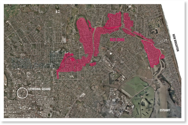
The Red Zone – showing the Christchurch East red zone from Cathedral Square to the estuary (image courtesy of the Canterbury Earthquake Recovery Agency).
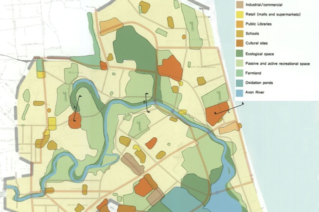
A plan showing how Christchurch East could be restructured with high-density housing on passive and active recreation space.
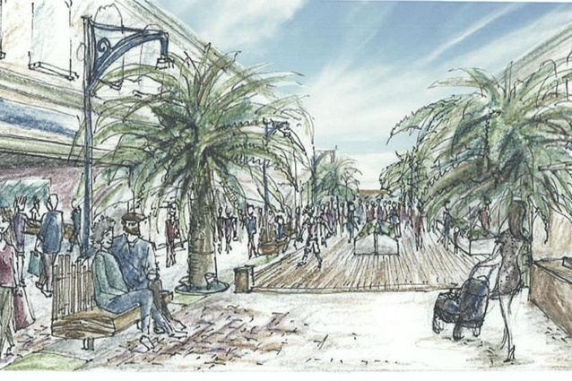
New Brighton Mall. A sketch of an intensified New Brighton Mall.
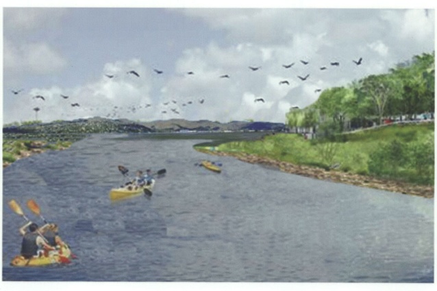
Water sports – a suggested view of water sports on the Avon River.
When it comes to structuring earthquake recovery in Christchurch East, should new houses be built on existing parks and golf courses, with displaced facilities rebuilt in a reactivated red zone?
The Christchurch earthquakes of 2010 and 2011 have caused unprecedented levels of damage, including collapsed and damaged buildings, rock falls, land subsidence and liquefaction. There has also been major infrastructure damage to streets, water supply and sewerage; some of which is still being repaired nine months after the magnitude 6.3 event of 22 February.
It is certain that the impact of the earthquake will be felt for years to come as the central city is made anew, houses repaired, the economy stabilised and in many instances lives rebuilt. However, while most people will have their homes repaired and will continue living in them, around 18,000 people living in the so called “red zones” of Brooklands, Pines Beach, Kaiapoi and eastern Christchurch will be displaced to they-know-not-where because the land their houses was built on was so badly damaged by liquefaction, subsidence, land-settlement and lateral spreading that it is more economical to knock these suburbs down than to stabilise the land they are built on.
The biggest of the red zones is the multi-suburb zone of eastern Christchurch, which runs along the Avon River from Richmond to the estuary (link to map), and affects about 500 hectares, around 5000 homes and approximately 13,500 residents. Demolition of houses in the area is expected to start in February 2012, but it is unclear where these people will be able to go, and despite many of the affected residents saying they want to continue living in the area, little work has been done in official circles to explore how this could be achieved. However, work by third-year students at Lincoln University’s School of Landscape Architecture has shown that with lateral thinking it is feasible to not only rehouse the displaced in their existing neighbourhoods, but to do so in a way that would turn Christchurch East around. In the process, this would overturn the area’s image as a less desirable part of the city, and create instead a series of richly enjoyable neighbourhoods and an open space structure of city-wide importance based around the open space opportunities that the red zoned land could provide.
The students spent semester two working on this project, moving through the scales to plan and design environmentally and socially sustainable housing and communities for the displaced citizens of Christchurch East. Underpinning their work were a raft of requirements, including that they address blue and green infrastructure, efficiencies of transport, the creation of strong local communities and the efficient use of land – in other words the usual drivers for sustainable design.
The starting point for the project was a series of cans, can’ts and soft-and-hard targets that the students developed. A 0.8 metre sea level rise was assumed (although this added only marginally to the 500 hectares of riverside red zone). Ecological values were quickly mapped and potentials highlighted. Existing social centres were identified and connectivity and linkages determined. Most critically, existing open space was identified and evaluated for its potential for housing.
Typifying post-war New Zealand, the suburbs of Christchurch East are low density, with only 10 households per hectare. Reproducing this within existing neighbourhoods was quickly seen as impossible because there isn’t enough potential building land, even assuming infill. But such a low density wouldn’t have worked anyway; it being both antithetical to the project’s sustainability goals and at odds with the multi-party-agreed Christchurch Urban Development Strategy, which seeks an average of 30 households per hectare in suburban centres. Adopting these greater densities reduced the area of land needed to 145 hectare, but even this wasn’t there.
It was soon apparent that the only way to re-house these displaced populations locally was with a conceptual land swap. This saw the students proposing that housing should be built on existing parks, golf courses and sports grounds, with these displaced facilities to be rebuilt in a reactivated red zone. Driving the detailed location of the housing was the ideal of people living within a short walk (taken as a kilometre) of the recreation opportunities the red zone would provide, and of living close to existing community centres. This was intended to create a walkable, and enjoyable, series of communities leveraging off existing strengths.
The resultant ideas have a pleasing potency in terms of both locations for housing and the significance of the red zone as open space. Using a range of densities from 15 to 80 households per hectare – but averaging around 35 – students were able to house people on around 140 hectare within comfortable reach of both existing neighbourhood centres such as New Brighton, Shirley, Richmond and Wainoni, and of the excellent open space opportunities the red zone would provide. By the end of the project these had grown to include sports fields, community gardens and allotments, walking, cycling and canoe trails, habitats for wildlife, sources of weaving materials and locations for fishing. And its reach had been extended the 800 metres from Richmond into the central city to stretch from downtown Christchurch to the sea.
These are of course just ideas, and finding an official audience for them has proved more difficult than might be expected. However, the work has been on display in The Palms shopping mall in Shirley – only a few hundred metres from the red zone – where it has found an interested and responsive audience. What will actually happen to the red zone is unknown – some people are saying it will never be built on, and others are suggesting it is just a matter of time. In the interim, community groups are rallying around the idea of turning the red zone into a significant open space for recreation and ecological benefit. This being Christchurch, it is certain that there will be long and heated discussion about how best to use this land. But in my view, the best case would be if it was part of a land swap that would both create a major open space network and provide local housing for displaced locals.