Seascapes and undersea landscapes
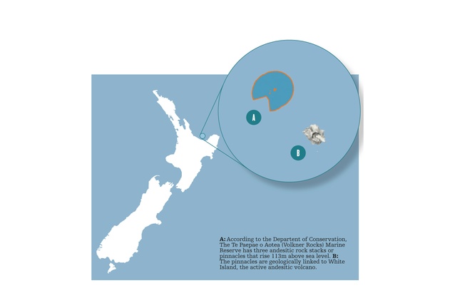
A: According to the Departent of Conservation, The Te Paepae o Aotea (Volkner Rocks) Marine Reserve has three andesitic rock stacks or pinnacles that rise 113m above sea level. B: The pinnacles are geologically linked to White Island, the active andesitic volcano.
It’s a busy world under the sea, and it’s set to get busier.
In June the Exclusive Economic Zone and Extended Continental Shelf (Environmental Effects) Act 2012 (“EEZ Act”) is expected to come into force. The Act puts in place a “Resource Management Act-like” regulatory framework for offshore activities, and its stated purpose is to “promote the sustainable management of the natural resources of the exclusive economic zone and the continental shelf. Interestingly, the Ministry for the Environment describes the purpose of the Act as: “to protect our oceans from the potential environmental risks of activities like petroleum exploration, seabed mining, marine energy generation and carbon capture developments.”
That purpose, from whichever view one sees it, will likely be put to the test, given that the Government has recently announced its support for the significant expansion of offshore oil and gas exploration; its Block Offer 2013 offers up 189,000km 2 of offshore area for that purpose. The Crown Minerals Amendment Act 2013 should also commence this month, introducing a new statutory purpose, being to “promote prospecting for, exploration
for, and mining of Crown owned minerals for the benefit
of New Zealand.”
Closer to shore, in February New Zealand King Salmon was controversially granted consents to expand its salmon farming operation in the Marlborough Sounds, in line with the aquaculture reform’s broad goal of kick-starting the aquaculture industry to greater export earnings profits.
While managing any adverse effects of commercial activities on undersea biodiversity and habitats is generally, and quite naturally, of most concern, consideration of seascapes and undersea landscapes also has its place.
The New Zealand Coastal Policy Statement 2010 (“NZCPS”) provides direction to decision-makers considering the impact of activities within the coastal marine area. The coastal marine area, and the jurisdiction of the Resource Management Act 1991 (“RMA”), extends 12 nautical miles offshore, where it meets and becomes the Exclusive Economic Zone. Section 104 of the RMA requires decision makers to have regard to the NZCPS, which includes Policy 15, the only policy to refer to “seascapes”. The policy identifies steps to be taken to “protect the natural features and natural landscapes (including seascapes) of the coastal environment from inappropriate subdivision, use and development.
“Seascape” is not defined by the NZCPS, does not feature under the RMA or the EEZ Act, and although fairly regularly referred to by decision makers, has not been subjected to any particular judicial analysis. The extent of seascapes is therefore up for debate, with opinion divided on their extension below the surface of the sea.
From a legal standpoint, underwater landscapes and subsurface features would not naturally fall within the term “seascape”. The dictionary definition of seascape is “a view of an expanse of the sea”, which is consistent with the approach the Environment Court appears to be taking to the concept.
In terms of international approaches, the Guide to Best Practice in Seascape Assessment , prepared for authorities in Wales and Ireland, and applied throughout the United Kingdom, extended that definition:
“…for the purposes of this guide we have broadened the concept and assumed the definition to include:
- Views from land to sea
- Views from sea to land
- Views along coastline
- The effect on landscape of the conjunction of sea and land.”
Even if that is the proper approach to the NZCPS, underwater landscapes and features are not irrelevant. Some underwater features, such as reefs, are of particular cultural significance and will be recognised in that context, and to the extent that an underwater environment is or could be utilised for recreational activities, adverse effects on that activity will be relevant under the RMA and presumably the EEZ Act, which has a largely undefined approach to effects.
Otherwise, if an underwater landscape is unusual or of particular beauty there is some scope in most decision-making processes to have regard to those values. The Marine Reserves Act 1971 enables the preservation of areas of New Zealand that contain underwater scenery, natural features, or marine life, of such distinctive quality, or so typical or beautiful, or unique that their continued preservation is in the national interest. In the Eastern Bay of Plenty, the Te Paepae o Aotea (Volkner Rocks) Marine Reserve for example, was found to warrant preservation to, in part, protect the spectacular underwater scenery of near vertical rock pinnacles, highlighted by unusually clear waters. Importantly however, the purpose of Marine Reserves is not to preserve the outstanding underwater scenery per se , but is for the scientific study of marine life. The primary focus therefore, is on biodiversity, with the preservation of natural state a beneficial bycatch of the process. As the Historic Places Trust observed in its submission on the Marine Reserves Bill; “Marine historical and cultural heritage is threatened by human activities in the marine environment such as marine farming and associated construction.” Yet, “the legislation fails to offer any protection for marine landscapes and places of cultural heritage of national importance.”
More successfully, some local authorities are utilising the broad purpose of the RMA to preserve underwater landscapes/seascapes within the coastal marine area. Although, or perhaps because, the Tasman District was at the forefront of enabling the aquaculture industry, the Tasman District Plan explicitly recognises the value of underwater landscapes/seascapes, identifying as an issue: “the appropriate form, scale or location of use or development in the coastal marine area that protects landscapes, including surface and underwater seascapes and natural features.” Corresponding rules seek to manage effects of disturbance, structures or works on landscape values in the coastal marine area. The Kaikoura District Council has also had regard to underwater landscape values by recognising in its plan the unique relationship between on-land geological features and the Kaikoura Canyon, a submarine canyon lying only 500m off shore and extending to depths of up to 1000m. The Department of Conservation has identified the canyon, which supports a variety of deep-water species, as a future World Heritage Site, observing that the government could, “take a long view and set a goal of bringing about the protection and integrated management of an ‘undersea-to-mountains’ natural state.”
While it will have to be seen whether the EEZ Act is able to respond to adverse seascape, and underwater landscape visual effects of major offshore commercial activities, it may be local authorities, like the Tasman District Council, that are best placed to address such effects, and those on sites of cultural heritage, in the coastal marine area.