Shifting a city: Ōtautahi 10 years on
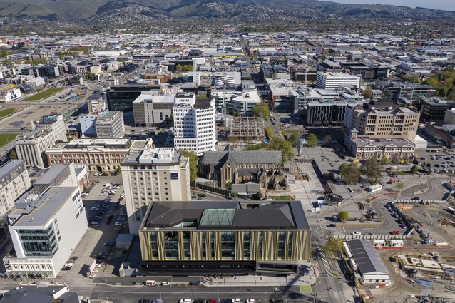
Matthew Webby notes that despite Government-led projects like Tūranga bringing people back to Cathedral Square, significant private development has yet to manifest.
Athfield Architects associate Matthew Webby maps the current state of Christchurch’s built form and reveals those areas of the city that have prospered and those that have not.
At the height of the last recession, jobs were few and far between. While my peers were flocking to the mining-driven boom in Australia, I packed my bags and headed south to Ōtautahi, Christchurch. This was January 2010. Little did I know that the somewhat-sleepy garden city set out in 1850 was about to undergo a seismic shift, in more ways than one.
The initial September 2010 earthquake felt catastrophic at the time but, looking back, its effect on the structure of the city was limited. Housing was extensively damaged and a significant number of predominantly brick buildings was lost, leaving many ‘missing teeth’ throughout the city. There was not, however, the opportunity to question the basic structure of the city. It was the February 2011 earthquake and aftershocks that resulted in a reported 80 per cent of the central city’s buildings being demolished, which fundamentally reset the course of Christchurch. Ten years later, this new direction is taking on a bold new shape but there remains a long way ahead.
The government’s response to the February 2011 earthquakes was to develop the Blueprint for the Christchurch Central Recovery Plan. Rapidly developed, the Blueprint set the course for unprecedented government investment and intervention in the central city through the establishment of ‘anchor projects’. These anchor projects were intended to influence the rebuild of the city and act as catalysts for private development and rebuilding. In the optimism of the Blueprint being rolled out, it would have been inconceivable that, 10 years on, there remain significant swathes of the central city yet to be touched by the rebuild effort and anchor projects yet to start construction.

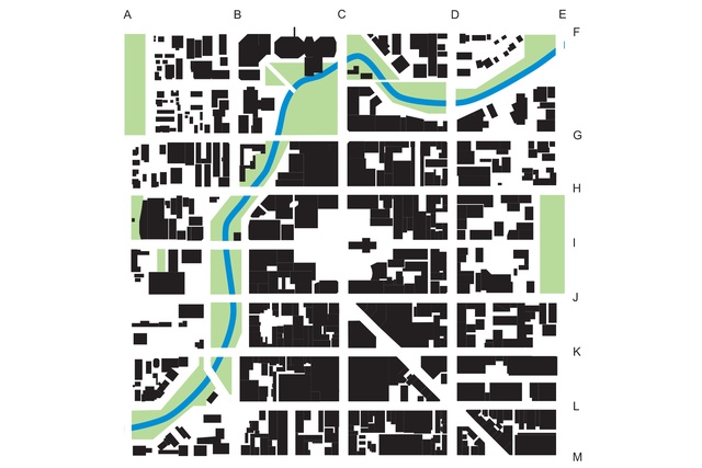
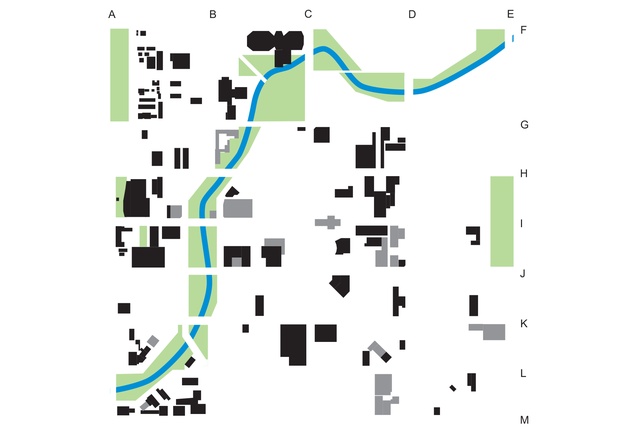
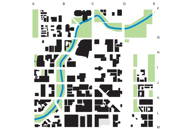
Fundamental to the reshaping of the city was the ‘East Frame’ anchor project, which saw government acquisition of the eastern third of the pre-earthquake central city. This zone, between Manchester and Madras Streets, is slowly being redeveloped into housing and greenspace, with the balance being land-banked for the future. The figure-ground mapping of Christchurch’s central city in 2010 and 2020 clearly demonstrates the effect that this simple idea has had on the shape of the city.
While the eastern part of the former city was being acquired and repurposed, the central city has been quietly shifting west, through sustained private investment around Cashel Mall and along the edges of Ōtākaro, the Avon River. In line with the changes in cities around the world that have rediscovered and reclaimed their waterfronts, this shift is of no surprise and was in motion before the quakes; however, the significant investment into the public realm along the banks of Ōtākaro, combined with that area being outside the demolition ‘red zone’, certainly accelerated this shift. The result is that current demand for office and retail space is now broadly satisfied via developments in the southern half of the central city. These blocks have achieved sufficient critical mass that seemingly unfeasible sites are now progressively being developed, providing some much-needed grain that the pioneering developments lacked. This is what the Blueprint envisaged.

What the Blueprint didn’t envisage was that, a decade on, there would be a near-absence of private investment to the north of Hereford Street, including around Cathedral Square, as shown in mapping highlighting only post-earthquake private development. This is despite the area being the location of three central and local government-led anchor projects, amounting to investment of more than half a billion dollars. Architectus and Schmidt Hammer Lassen Architects’ Tūranga (central city library) is one such project. Tūranga opened its doors in late 2018 and has certainly brought people back to this area but significant private development is yet to manifest.
The area has two yet-to-be-completed anchor projects: Te Pae, the new convention centre, set to open in late 2021, and the Performing Arts Precinct and associated new Court Theatre, set for opening late in 2023. These significant projects will, without doubt, provide a much-needed boost to this northern part of the central city. This question stands, however: What will it take for landowners and developers to have confidence to rebuild in this area and, with office and retail spoken for, what opportunities does this area hold?