Anti-social distancing

Dr David Turner argues that higher-density detached house-types that are permissible under the Auckland Unitary Plan do little for occupants in terms of privacy and do not help the region meet its densification goals.
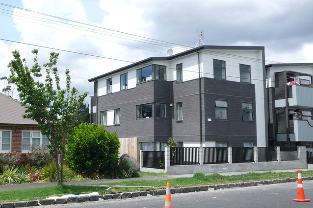
Figure 1: 15–23 Rawalpindi Street, Mt Albert.
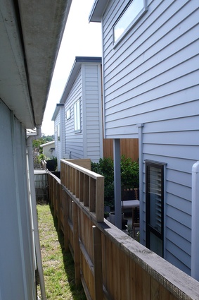
Figure 2.1: 125 Point Chevalier Road north boundary.
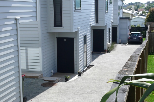
Figure 2.2: 125 Point Chevalier Road south access drive.
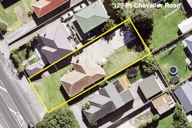
Figure 2.3: 125 Point Chevalier Road site plan diagram.
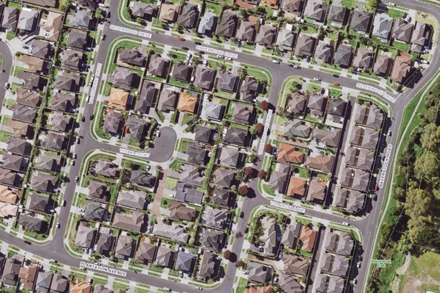
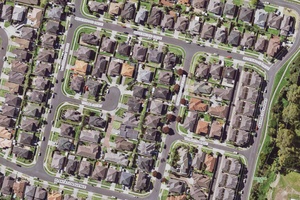
Figure 3: Flat Bush – a typical block on Greenbrooke–Woodberry Drive.
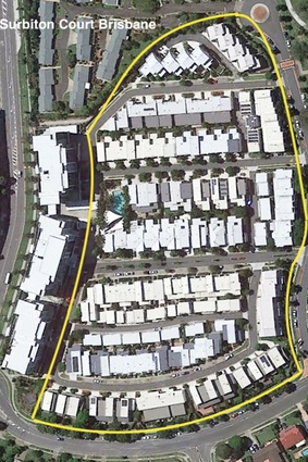
Figure 4: Celestial Court, Brisbane, 2008.
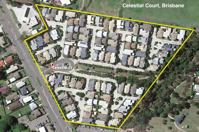
Figure 5: Surbiton Court, Brisbane, 2016.
In this excerpt from the 2020 iteration of Unitec Institute of Technology's recently re-imagined, peer-reviewed journal, Asylum, Dr. David Turner revisits Auckland's Unitary Plan and explores how the housing density changes implemented by it have affected urban development since 2016.
The Auckland Unitary Plan (AUP) that came into force in November 2016 revised the rules for housing design across the city’s region, introducing new paradigms, and unifying regional policies for the development of form, growth and density around a general objective of urban sustainability. Two of the Plan’s three prime purposes are stated: (1) [The Plan] describes how the people and communities of the Auckland region will manage Auckland’s natural and physical resources while enabling growth and development and protecting the things people and communities value; (2) [the Plan] provides the regulatory framework to help make Auckland a quality place to live, attractive to people and businesses and a place where environmental standards are respected and upheld.1
The Plan proposes to intensify the city, aiming to achieve a 30:70 balance between peripheral new house-building and developments within the existing metropolitan urban limit (MUL).2 These policy settings are intended to contain sprawl, are endorsed by all the principal participants in the political arena as well as iwi and community groups, and align with urban planning theories that advocate for sustainable ‘compact’ cities. Crucially, the AUP dispenses with density classifications in large areas of Auckland’s older central suburbs: development is now regulated by rules that reduce earlier minimum site sizes, set-backs and external space, and increase allowable building heights.
It is suggested here that after three and a half years the objectives of the AUP are visible, and can be qualitatively evaluated as preliminary evidence of new housing developed through the mechanisms of this legislation. The many dimensions of sustainability that contribute to the AUP’s general objectives include issues that are touched on, but not explored in detail in this paper: here, a review of the early stages of the forms of urban housing emerging from the Plan is proposed, focusing on an analysis of two typologies: stand-alone house types, and low-rise walk-up apartments. The central concerns are those fundamental to housing development: identity, privacy and, in New Zealand’s housing culture, the protections for ownership and property value enshrined and underwritten in legislation.
Housing under the AUP
The scale of change proposed in the AUP, particularly the density of housing, its spatial proximities, permitted heights and relationships to the street, is introducing the city’s residents to radically new conditions. The Plan continues to recognise and prioritise the socioeconomic value associated with private property ownership, but the city’s way of urban life and its physical landscape are changing rapidly.
Generally, these new conditions have been accepted without protest. Auckland’s traditionally wooded suburbs that have been endowed by mature backyard planting from three or more generations are steadily disappearing, as council protection, even for native trees, is removed. More of the city’s suburban surface is becoming impermeable: when Joni Mitchell protested that “they paved paradise / and put up a parking lot” she could have had twentyfirst century Auckland in mind.
Auckland’s inflated property values are affected by intensification, in some cases negatively, and although ‘nimby-ism’ is occasionally evident it is not a significant obstacle to the AUP. Responses to increased physical proximity have varied: the impact of a large building on a single-storey street, consented under the AUP without notification, has occasionally attracted some alarmed comment, but there is general acceptance in the community of both the policy to intensify, and of the outcome.3
In combination, and along with technologies that are changing work and retailing patterns, and increasingly well-used public transportation systems, these intensifying strategies are transforming Auckland’s urban characteristic: the city is moving towards the spatial style of the Pacific rim cities we admire, including Sydney, Melbourne and Vancouver. Auckland is visibly, and in real time, outgrowing its suburban history.
Intensification housing typologies under the AUP
From a small range of typologies that can be used in higher density housing the standard is being set by two generic models: a variation of the three-storey walk-up apartment block used in Australia (known there as the ‘six-pack’ block), and two-storey stand-alone houses on single sites, taking advantage of the relaxation of previous rules governing minimum section sizes. A third, higher-density typology, ‘row’ housing in blocks of terraces in two- or three-storey form, is also used widely, but is excluded from this analysis for reasons of editorial space.4 Housing terminology continues to be imprecise, but these typologies define most new housing under the AUP.
Small apartment blocks make the greater visual impact on typical low-scale neighbourhoods. The typology is being used extensively by Kainga Ora (formerly Housing New Zealand), often replacing two or three detached houses from the state housing stock with up to twenty apartments.
This ratio achieves the AUP’s intensification objective by increasing density from nine or ten dwellings per hectare (dph)5 to 70–100 dph, using a house-type that meets the demands of smaller households, and one that involves lower maintenance and capital costs.6 Three-storey apartment blocks in this density range are able to include practical ratios of parking on site, usually one space per unit, without expensive underground garaging, and can manage good standards of privacy between units, adequate outlook from habitable rooms, and a modest provision of public external space for residents.
The production of these buildings has resulted in changes to the traditional systems and structure of the building industry. Apartment building projects are now using nontraditional technical solutions to multi-storey housing construction, including prefabricated panelised crosslaminated timber (CLT) systems, and hybrid construction that integrates precast or poured concrete elements with timber framing.
From observation it would seem that speed of construction and cost saving are significant advantages with these methods. Although it is a surprise to see weatherboard cladding on some of these developments, external wall choices in the post-leaky-building era are justifiably conservative, and weatherboards help to preserve a suburban aesthetic; visually, they mitigate the impact of large new buildings on suburban streets.
Alongside advances in their building technologies, housing providers have evolved their operational systems with the AUP: rather than scores of builders producing a handful of units per year, some developers now have the capacity to supply hundreds of units, with many variations. The apartment typology is most suited to either corner sites or sites with long street frontages, using a dual aspect crossventilated plan with vertical circulation between paired apartments at each floor level. This model is appearing extensively in the public housing sector. Where the typology has been designed on a deep, narrow-fronted site (with, for instance, a standard 15–18m suburban streetedge dimension) the preferred dual-aspect plan is less able to maximise the value of its basic characteristics.
The main alternative plan is arranged with access from a balcony served by vertical circulation (stairs and lifts if included) at the ends of the block. This imposes severe compromises on privacy of rooms opening onto the balcony in cross-ventilated plans, but is an economic model widely used in the private sector. Developers in this sector include Ockham Residential, who are carrying out joint developments with iwi, and NZ Living, a company that has rationalised its plan designs to minimise uncertainty in project pricing.
A selection of examples of apartment blocks built and occupied since the AUP was adopted in 2016 includes 15–23 Rawalpindi Street, 1 Tasman Road (both in Mt Albert, the latter a fast-tracked CLT project), and 30–34 Hutchinson Avenue (New Lynn), all Kainga Ora schemes; and NZ Living’s 340 Onehunga Mall Road.7 These four projects have replaced fourteen single-storey dwellings with a total of ninety-three apartments, at an average density of 95 dph, and between them supply housing for up to two hundred and forty people in a mix of public and private units (Figure 1).
Typology selection and density
The second typology to appear in significant numbers is the stand-alone two-storey house occupying a minimum area of land. Under previous regulations stand-alone housing was limited by minimum site area to densities of less than 30 dph, and it represents suburban housing in the sense that individual, rather than shared, values are explicit. It aligns with a suburban-oriented market preference for separate buildings, which appears to stem from embedded preconceptions – that separate buildings continue the habit of individuation through separate land titles, and that the owner can make independent decisions about maintenance, or even in the longer term, demolition and replacement.
Other perceptions include the notion that the typology offers greater privacy, and this has been encouraged by the real estate industry in the belief that detached houses have higher value. Stand-alone houses attract investors, largely for these reasons, thus expanding the potential market for the developer.

Scores of ‘infill’ projects in this form are now appearing on suburban sections. The standard model is a two-storey detached house, with its floor space maximised according to now reduced set-back and height-to-boundary regulations: a total of up to 1000m2 of new housing might replace the 100–120m2 of the earlier building. Side yards in the new layouts are governed not by dimensions that provide for privacy, but by the minimum space needed for building access. There are no gardens: private open space is reduced to under a metre of land between house and fence, and a shared concrete driveway for the secure on-site car parking that identifies the new house with the suburban model.
Typically, at 125 Point Chevalier Road a 617m2 section with one house (density 14 dph) has been redeveloped for four stand-alone units. Under regulations in force before 2016 the permitted intensification density would have been 28 dph; four units now increase the density to 56 dph. The new regulations are illustrated by their external spaces, shown in Figure 2.
The 1700ha Flat Bush development offers many further examples of the house type, where they were initially justified by a fashionable planning theory that advocated for higher densities in suburban housing. One typical block, between Greenbrooke Drive and Woodberry Drive, illustrates this layout type and demonstrates that density cannot be increased beyond the range of 22–25 dwellings per hectare without a reduction of unit sizes (Figure 3).
Several Australian-based volume house-builders familiar with this type of compressed layout are active in Auckland’s supply process. Their approach is illustrated by the 2008 Celestial Court scheme of ninety-one houses in Brisbane, located in a mid-priced central neighbourhood. An overland flow-path occupies the core of the site, with housing on the remainder at a net residential density of 22 dph overall, and 30 dph excluding the area of the park (Figure 4).
Houses in this block are large two-storey units with some single-storey extensions, double garages, and small set-backs; side yards are less than one metre wide, and rear spaces are minimal for any domestic purpose. More recent urban housing in Australia gains higher densities in layouts that use a mix of apartments and terraced housetypes. An example in the same suburb as Celestial Court is Surbiton Court, in Carindale, completed in 2016. This layout has a density of approximately 50 dph for the twostorey terraced housing (excluding the mid-rise apartment blocks), achieving more efficient land use and providing more privacy and more useable external spaces (Figure 5).
Problems associated with these higher-density detached layouts have been anticipated in studies in Australian planning for some time. The extreme reduction of private external space that results from loss of set-back rules, coupled with the developer’s readiness to increase floor areas for sales purposes rather than any apparent domestic practicality, has been criticised in Australian literature for some time, particularly in Victoria.8 A gradual tightening of design guides appears to be the main response by the authorities.
Public interest in developments built for the investment market in Australia also has a smaller influence on supply than it does in New Zealand, where, for politically ideological reasons, the tax system is more generous towards this ‘build to rent’ element of new housing. Investors, who currently represent about 40 per cent of the market for new higher-density houses in Auckland, are thought to have been among the buyers of the Point Chevalier development.
Typology, density and urban form
Earlier in this paper the highest density possible with the detached house-type in Auckland prior to the AUP was stated to be 30 dph, measured by the net residential system including space needed for the apportioned road space that connects a development to the rest of the city. The Flat Bush average density achieved by this typology is similar to the net density figure for the Celestial Court, Brisbane, example, at about 22 dph with slightly higher density possible in some cases.
For the purposes of the AUP, developers using this typology are presented with significant and irreconcilable disadvantages when sustainability criteria are applied. Higher density detached house-type layouts illustrate the loss of the social amenities that initially defined the attractions of detached housing: the very qualities inherent in the typology are progressively diminished as density and unit sizes increase. Firstly, many layouts sacrifice privacy – distances reduce to the point of extreme discomfort, with windows close to boundaries and exposed to windows in the adjoining property. Private enclosed gardens for children, the washing, the dog and the lemon tree are dispensed with.
At 25 dwellings per hectare, housing development does not make intensive use of land or contribute to the housing numbers needed in cities pursuing intensification policies: these schemes are evidence that detached housing is capable only of a model that supplies large floor areas at sub-urban densities. Within the present demographic pattern of progressively lower occupancy rates, housing at this density does not populate the suburb with enough people to satisfy the policy’s purposes.
Anti-social distancing in the processes of intensified city planning

Many intensification developments have been completed in the four years since the AUP was adopted; numerous others are in progress. At this stage it is relevant to ask what building forms the policy-makers intended when they agreed to abandon density constraints on housing development.
A fundamental principle of urban planning is the legally ordered spatial arrangement that aims to treat every property owner fairly, an intention that is justified by social and political theory in an egalitarian society such as that in New Zealand. Conscious of manipulations of development rules in the past, the Plan’s authors have to anticipate consequences in order to eliminate loopholes and opportunities for short-cuts; this particularly applies to those that create disadvantage for neighbours and other developers.
The Unitary Plan came with expectations that it had taken account of changes in the way we want to live, shop, work, drive and form neighbourhood relationships. Although consultation with industry helps in this process, it is unlikely that all possible outcomes can be predicted, and it is hard to believe that the housing standards of these sub-quarter-acre stand-alone mini-projects has been anticipated.
Intensification policies address a catalogue of interconnected environmental issues that have validated the compact city planning concept overseas, and the AUP’s stated objectives will be gradually achieved: higher population density, fewer encroachments on productive land, lower levels of investment in roads, sewers and power lines. There are more people to use public transport services, and the shorter commuting distances suited to electric bikes and scooters reduce car dependence, traffic congestion and noise, and improve air quality. However, policies also need to ensure that housing quality reaches the highest possible standards for the city’s future.
Conclusions and implications
While development controls related to the key principles of the AUP involve complex design and planning decisions, two issues stand out in this analysis. Privacy has been one of the defining characteristics of the New Zealand housing culture since urban settlements became the way of life for the majority,9 and is proving to be a problematic amenity at higher densities: apartments can be designed for privacy but it is less attainable with detached house-types.10
Rapoport’s concept of affective density – the perception of crowding that registers excessive proximity, of a sense of ownership, of identity, of opportunity to be separate as well as part of the community, and of self – is thoroughly compromised by over-close spatial planning.11 As examples described here show, detached layouts at densities that reduce privacy to a gesture of meaningless separation are now permitted without notification under the AUP.

The more serious issue, however, is the effect on the future of the intensification programme, when property development rights are extended to other owners. An inescapable consequence is that once the right to develop in this pattern is granted, the same rights can be claimed by neighbouring properties.
Several problems stem from this extension to others. Firstly, the city needs a natural environment with a quantum of trees, gardens and grass to sustain bird and insect life and provide shade, with landscape to cool the heat island, and soft ground to absorb rainfall. Most of this provision comes with private property, but none is protected in the planning model that allows stand-alone housing at higher densities.
Secondly, and while there is private profit to be gained, neither the city nor the community benefits: these projects, although dense within their own sites, only raise neighbourhood densities to twenty or so dwellings per hectare. Density increases at this level will not meet Auckland’s targets of 70 percent of supply within the MUL.
Furthermore, they will not achieve the Plan’s ambition of comprehensive urban sustainability; rather than break down the highly fragmented pattern of ownerships in the suburban grid (which obstructs economically viable intensification), such developments will multiply that fragmentation, making future consolidation more problematic.
Reversing legislation is difficult. But in the present circumstances of a weaker economy, a temporary result of the coronavirus pandemic, it is possible to call a halt to small over-compressed developments, and to insist that future housing is informed by examples of high-quality higher-density housing seen in Europe, Australia and New Zealand. A density ceiling that relates house-types to site areas would reset the parameters for intensification projects on small sites, and reinstate some of the objectives of the AUP’s sustainable agenda.
This article was first published in Asylum, the Unitec Institute of Technology’s recently re-imagined yearly journal. The 2020 iteration of the journal now includes not only student work from the Bachelor’s and Master’s of Architecture programmes, but also student work in the Interior Design and Landscape Architecture programmes and a selection of peer-reviewed research. Click here to read the full journal online.
1. Auckland Council, “Chapter A. Introduction,” in Auckland Unitary Plan Operative in Part 2, Read here.
2. The AUP is a continuously changing document, operative in part in all stages of application; this paper refers to the Plan as it stood (July 14, 2020) but uses previous versions where subsequent alterations to wording do not affect the meaning or intention of the Plan relating to housing development.
3. In the latest summary, Newsroom collated opinions from politically left and right commentators in Dileep Fonseka’s article, “The ‘Lefties’ Who Want Less Housing,” Newsroom, August 28, 2020, https://www.newsroom.co.nz/the-lefties-who-want-less-housing.
4. Hobsonville, Stonefields and Long Bay all develop to a master plan in which house types are mixed.
5. In this study, density is measured using the net residential system, which includes half of the road frontage providing access to the site in the site areas calculated, following the AMCORD 1995 definition; site areas are therefore not those stated in the application details. Commonwealth Department of Housing and Regional Development, AMCORD: A National Resource Document for Residential Development (Canberra: Australian Government Publishing Service, 1997), https://www.creationcorporation.com.au/AMCORD/AMCORD/AMCORD.PDF.
6. Linda Meade et al., for Deloitte (2018), identified this development model as the least expensive form of construction. Linda Meade et al., Cost of Residential Housing Development: A Focus on Building Materials (Auckland: Deloitte Touche Tohmatsu, 2018).
7. “Welcome to 340 Onehunga Mall,” NZ Living, 2019, https://www.nzliving.net/340-onehunga-mall/.
8. Robert Birrell, Kevin O’Connor, Virginia Rapson, and Ernest Healy, Melbourne 2030: Planning Rhetoric Versus Urban Reality (Melbourne: Monash University ePress, 2005).
9. Gael Ferguson, Building the New Zealand Dream (Palmerston North: The Dunmore Press, 1994).
10. David Turner, “Planning for Higher Density: Concepts of Privacy in Auckland’s Culture of Housing” (PhD thesis, The University of Auckland, 2010), https://catalogue.library.auckland.ac.nz/permalink/f/ta4ieu/uoa_alma21195771330002091.
11. Amos Rapoport, “Toward a Redefinition of Density,” Business and Behaviour 7, no. 2 (1975): 133–58.